Features
Thursday, February 9th, 2012
Sea ice is an important contributor to global climate changes. Specifically, sea ice thickness helps to understand ocean circulation and heat transfer. The ability to capture more information about global sea ice thickness has advanced considerably and...
Wednesday, February 1st, 2012
The Surveying, Geographic Information and Map Division in China asserted it's overall 2012 strategy this past week at a plenary meeting. Min Yi-jen acted as deputy director of the meeting, which focused upon new requirements and a...

Friday, January 27th, 2012
Intergraph and ERDAS are two well known brands in the geospatial industry. Recently Hexagon AB purchased Intergraph for $2.1B USD, effectively bringing GeoMedia GIS software into the wider Hexagon domain - filling a large hole across the...

Thursday, January 26th, 2012
The issue of open data, accessible and available, has long been source of discussion for many participants involved in the geomatics and geospatial industry. There are many reasons for data being confined including data formats, policy, lack...

Thursday, January 26th, 2012
The U.S.-based Urban and Regional Information System Association (URISA) has been coordinating global volunteer mapping projects since 2003. To date there have been 80 missions with nearly 250 volunteers deployed on such projects as disaster response, GPS...

Friday, January 20th, 2012
This past week saw Apple announce a new initiative that would bring the iBook more closely to the world of education and student use. At the same time, the company announced a new iTunes App that would...
Thursday, January 19th, 2012
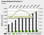
Fugro, a global geospatial and geoscience services company trading on Euronext Amsterdam, took the opportunity at the start of the year to reflect on the turbulence of 2011 as well as their contiued growth. The company achieved...

Wednesday, January 18th, 2012
Nexteq Navigation is a leading developer of Precise Point Positioning (PPP) technology. This GNSS approach aims to provide high-accuracy positioning through the use of a single receiver involving satellite derived global corrections. The company's 'Freedom' technology provides...

Thursday, January 12th, 2012
Topographic data is an important piece when it comes to the design process. Very places on the planet are completely flat. Housing, roadways, utilities, pipelines and many other features are oriented on the landscape with respect to...

Wednesday, January 11th, 2012
A warm, humid Monday morning marked the beginning of an expedition to the Niah Caves, located in Sarawak, East Malaysia. Involving academics from several institutes of higher learning, hailing from three different continents, this study trip was...
