Asian Surveying & Mapping
Breaking News
South Korea is converting an abandoned coal mine into a moon exploration testing ground
South Korea is transforming abandoned coal mines into testing...
ISRO to Launch Chandrayaan-5 With Japan, Plans Space Station
Dr. V. Narayanan, Chairman of the Indian Space Research...
Russia and China are threatening SpaceX’s Starlink satellite constellation, new report finds
SpaceX's Starlink satellite constellation is facing threats from Russia...
China and Pakistan agree to fly 1st foreign astronaut to Chinese space station
For the first time, the Chinese space program will train...
ISRO’s “Space on Wheels” offers a peek into Indian Space Programme to students in Karimnagar
The Indian Space Research Organisation (ISRO)’s “Space on Wheels”...
Geospatial led solutions build the foundations for better decision-making
Geo Connect Asia 2025 paves the way for turning...
GEOSA, Singapore Land Authority Launch Achievements of Joint Geospatial System Project
Riyadh, SPA -- The General Authority for Survey and...
Building in Bangkok collapses as powerful earthquake hits southeast Asia
One person has died and 50 were injured in...
Bellatrix Aerospace Partners with Astroscale Japan for Space Debris Removal
Bellatrix Aerospace, a Bengaluru-based space mobility company, has joined...
NSTC announces Pingtung site as Taiwan’s space mission launch center
Taipei, March 26 (CNA) Taiwan's National Science and Technology...
Tsunami Radar

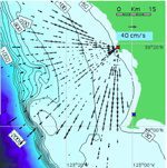
The primary purpose of HG radar observations are to tell real-time offshore ocean circulation, but after looking closely at records from a few of the 80 HF radars that operate along the US Pacific coast and along the coast of Japan, researchers were able to see tsunami-induced wave velocities.

Radars in Hokkaido in Japan show tsunami measurements in their records. In California, the Coastal Ocean Currents Monitoring Program, a network of coastal radar devices, were able to detect the March 11 tsunami. The radar could offer hours of advance warning in Japan, but less than a half-hour warning in California due to the steeper sea floor bathymetry. This was the first time that a tsunami has been tracked by radar, and could prove to be a useful means of detection for future incidents.

The radar detection results are outlined in this paper published in the journal Remote Sensing.