Asian Surveying & Mapping
Breaking News
Uttar Pradesh Govt launches Special Land Measurement Campaign
The Uttar Pradesh government yesterday launched the statewide Digi...
Japan Eyes Sovereign D2D Satellite Network
Japan plans to select a proposal this month for...
China schedules Long March 10B rocket launch and recovery attempt
HELSINKI — China is set for a debut flight...
BRICS space agencies meet begins in Bengaluru
Heads and senior representatives of the space agencies of...
“India’s growing space ecosystem to drive global collaboration”, says ISRO Chairman V Narayanan after BRICS Space Agencies Meeting
"India's growing space ecosystem to drive global collaboration", says...
UAE aims to see Emirati on Moon in next 10 years, says MBRSC chief
UAE expects to have a presence on the Moon within...
Safran, SatSure partner to develop geospatial intelligence solutions for India
French aerospace giant Safran Electronics & Defense and Indian...
Singapore unveils road map to help develop international business standards and conformance
Singapore has unveiled plans to help develop international standards...
Adelaide University to run space and defence venture launchpad ahead of Australian Space Forum
Adelaide University’s Innovation & Collaboration Centre (ICC) will deliver...
Japan’s H3 rocket returns to space with successful launch after December setback
Japan’s flagship H3 rocket has returned to flight six...
  • Jun 23, 2025
  • Comments Off on India To Launch $1.5 Billion Joint Earth Mission with NASA In July 
  • Feature
  • 9581 Views

June 23rd, 2025
India To Launch $1.5 Billion Joint Earth Mission with NASA In July 

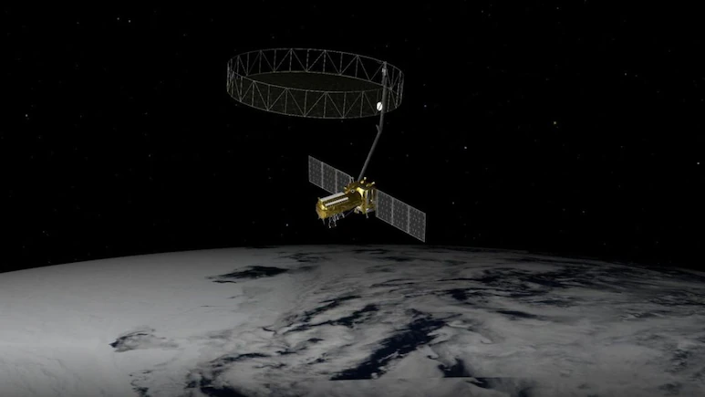
The $1.5 billion Earth-observing satellite, weighing nearly three tonnes, will monitor the planet’s surface with unmatched precision, using advanced radar to scan land, ice, and water every 12 days. 

Jointly developed by NASA’s Jet Propulsion Laboratory and ISRO’s Space Applications Centre, NISAR is the world’s first Earth-observing satellite equipped with dual-frequency radar, L-band and S-band. Using Synthetic Aperture Radar (SAR) technology, it will actively beam radar signals to Earth and analyse the reflections to create high-resolution images. Unlike optical satellites that depend on sunlight and clear skies, NISAR can capture data day or night, and even “see” through cloud cover, smoke, or dense vegetation. 

Image Credit: NDTV