
Tuesday, May 4th, 2021
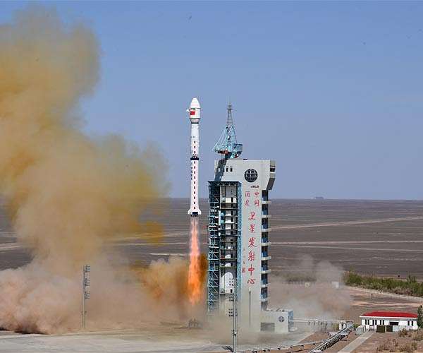
China launched a new remote-sensing satellite, Yaogan-34, into space from the Jiuquan Satellite Launch Center in northwest China on April 30, 2021. The Yaogan-34 satellite was carried by a Long March-4C rocket and successfully entered its planned...
Tuesday, April 20th, 2021
Surigae is not expected to make landfall, but the typhoon churning in the Western Pacific Ocean is already a significant storm. When the storm rapidly intensified to category 5 strength on April 17, 2021, it marked the...

Monday, April 5th, 2021
Adelaide-based satellite manufacturer Fleet Space Technologies successfully launched its fifth commercial nanosatellite and is looking to expand production in Australia. Named Centauri 3, the 10-kilogram nanosatellite was launched from New Zealand’s Launch Complex 1 at Mahia Peninsula...

Tuesday, March 23rd, 2021
Dubai Municipality announced the successful launch and deployment of DMSat-1, an atmospheric monitoring microsatellite built by Space Flight Laboratory (SFL). DMSat-1 launched on March 22, 2021, from the Baikonur Cosmodrome in Kazakhstan aboard a Soyuz rocket. SFL...
Tuesday, March 9th, 2021
Although it covers just 1 percent of Earth’s land surfaces, Indonesia’s rainforest is believed to shelter 10 percent of the world’s known plant species, 12 percent of mammal species and 17 percent of bird species. Spread across...
Monday, February 22nd, 2021
PSLV-C51, the 53rd mission of ISRO’s PSLV, will launch Amazonia-1 of Brazil as the primary satellite with 18 co-passenger satellites from Satish Dhawan Space Centre (SDSC) SHAR, Sriharikota. The launch is tentatively scheduled for Feb. 28, 2021,...
Tuesday, February 9th, 2021
GfK released a new and completely overhauled digital map edition for all of Asia. The edition features coverage of 49 countries, ranging from the three BRICS nations Russia, India and China to smaller countries such as Bahrain...
Tuesday, January 26th, 2021
Led by the SmartSat Cooperative Research Centre (CRC), the AUD$6.5 million SASAT1 Space Services Mission was announced in Adelaide, South Australia. Based at Lot Fourteen, which is also home to the Australian Space Agency, the SmartSat Cooperative...

Tuesday, January 12th, 2021
In an online event organised on Jan. 11, 2021, Department of Space and Atal Innovation Mission, NITI Aayog announced that ISRO will be adopting 100 Atal Tinkering Labs (ATLs) across the country, out of which 45 ATLs...
Monday, December 7th, 2020
For decades, NASA has used the vantage point of space, combined with airborne and ground-based field campaigns, to decipher the impact of air pollution and help other agencies protect people when unhealthy air threatens the places they...