Asian Surveying & Mapping
Breaking News
Intermap Announces $1 Million Program in Malaysia and Business Updates
DENVER – Intermap Technologies (TSX: IMP; OTCQB: ITMSF) (“Intermap” or...
From Kuala Lumpur To Singapore: Malaysia’s High-Speed Rail Resurgence Sparks China’s Pan-Asia Vision
The Malaysian government is once again working on building...
Japan’s Synspective successfully launches fourth SAR satellite
Synspective, the Japanese provider of Satellite/Synthetic Aperture Radar (SAR)...
South Korea’s Joowon Industrial Selects Aeva 4D LiDAR for Automated Power Line Inspection Program
MOUNTAIN VIEW, Calif. & SEONGNAM CITY, South Korea- Aeva®...
Synspective’s SAR Satellite, StriX-3, Successfully Reaches Its Target Orbit and Spreads Its Wings
TOKYO, 2024, March 13 – Synspective Inc., a SAR...
Indian Prime Minister Narendra Modi Commissions Genesys Digital Twin Map Stack in His Parliamentary Constituency
Mumbai: The Prime Minister of India, Mr. Narendra Modi, recently...
Geo Connect Asia 2024 to unveil geospatial’s transformative power
Geo Connect Asia (GCA) is set to return to...
Iran launches ‘domestically developed’ imaging satellite from Russia
The launch of Pars 1 is fourth this year,...
Astranis relocating hobbled debut satellite from Alaska to Asia
TAMPA, Fla. — Astranis is moving its debut satellite...
Asia space race heats up as China, Japan and India reach for the stars
After another year of US aeronautics company SpaceX dominating...

PSLV-C51, the 53rd mission of ISRO’s PSLV, will launch Amazonia-1 of Brazil as the primary satellite with 18 co-passenger satellites from Satish Dhawan Space Centre (SDSC) SHAR, Sriharikota. The launch is tentatively scheduled for Feb. 28, 2021, subject to weather conditions.

PSLV-C51/Amazonia-1 is the first dedicated commercial mission of NewSpace India Limited (NSIL), a Government of India company under the Department of Space. NSIL is undertaking this mission under a commercial arrangement with Spaceflight Inc. USA.

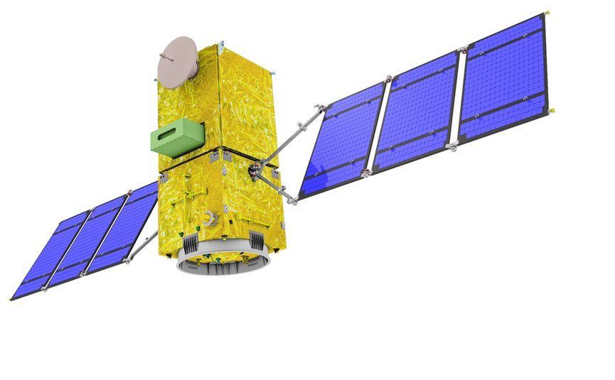
Amazonia-1 is the optical Earth observation satellite of National Institute for Space Research (INPE). This satellite would further strengthen the existing structure by providing remote-sensing data to users for monitoring deforestation in the Amazon region and analysis of diversified agriculture across the Brazilian territory.

The 18 co-passenger satellites include four from IN-SPACe (three UNITYsats from a consortium of three Indian academic institutes, and one Satish Dhawan Sat from Space Kidz India) and 14 from NSIL.