Friday, August 12th, 2022
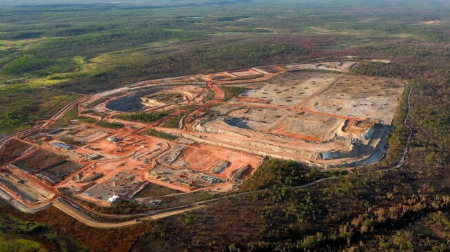
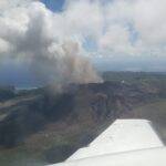
Fleet Space Technologies announced the successful completion of a trial using its proprietary ExoSphere Ambient Noise Tomography (ANT) technology to faster and non-invasively find critical lithium deposits. This was commissioned by Australia’s newest lithium miner, Core Lithium,...

Monday, August 1st, 2022
ISRO participated in Digital India: Catalysing New India Techade event organized by the Ministry of Electronics and Information Technology (MeitY) from July 4-10, 2022, at Gandhinagar. During the event, ISRO showcased its important contributions toward providing space-based...

Monday, July 18th, 2022
Infrastructure Cook Islands (ICI) contracted with Woolpert to collect topographic and bathymetric lidar data and aerial imagery across the Cook Islands. The multimillion-dollar contract is funded by the New Zealand Ministry of Foreign Affairs and Trade and...
Friday, July 1st, 2022
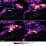
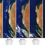
Bangladesh has a long history of deadly and costly storms. Among the most worrisome are kalbaishakhi, small but powerful storm cells that tend to affect the country in the spring. Kalbaishakhi were responsible for a 1989 tornado...

Monday, June 20th, 2022
Cashmere: it’s an iconic part of luxury fashion and a silky soft way to keep warm in the winter. But there’s a lot to unravel about the way it’s made. Cashmere wool comes from goats living in...
Tuesday, June 7th, 2022
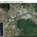
The Saga Prefecture and Japan Aerospace Exploration Agency (JAXA) signed a cooperation agreement on March 22, 2021, to solve regional issues with space technologies. They have been jointly promoting various initiatives under the "Space x Regional Revitalization”...
Tuesday, May 24th, 2022
Woolpert was contracted by the Pacific Community (SPC) to acquire, process and deliver topographic and bathymetric lidar data and aerial imagery for Vanuatu, a nation of multiple islands in the South Pacific. The project, funded by The...
Tuesday, May 10th, 2022
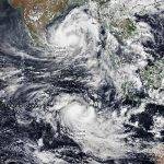
A pair of tropical cyclones, one on each side of the equator, is putting on a show for satellites passing over the Indian Ocean. On May 8, 2022, the Visible Infrared Imaging Radiometer Suite (VIIRS) on NOAA-20...
Wednesday, April 20th, 2022
The SeaHawk satellite is a very small satellite designed to monitor ocean color and coastal ecosystems. It measures just 10 centimeters by 10 centimeters by 30 centimeters and flies in a polar orbit at 585 kilometers (363...
Monday, April 11th, 2022
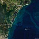
Just more than three months into 2022, Sydney, Australia, has already received a year’s worth of rain. The recent deluge brought more flooding to the already rain-soaked southern and central coasts of New South Wales, prompting evacuations....
