Asian Surveying & Mapping
Breaking News
Intermap Announces $1 Million Program in Malaysia and Business Updates
DENVER – Intermap Technologies (TSX: IMP; OTCQB: ITMSF) (“Intermap” or...
From Kuala Lumpur To Singapore: Malaysia’s High-Speed Rail Resurgence Sparks China’s Pan-Asia Vision
The Malaysian government is once again working on building...
Japan’s Synspective successfully launches fourth SAR satellite
Synspective, the Japanese provider of Satellite/Synthetic Aperture Radar (SAR)...
South Korea’s Joowon Industrial Selects Aeva 4D LiDAR for Automated Power Line Inspection Program
MOUNTAIN VIEW, Calif. & SEONGNAM CITY, South Korea- Aeva®...
Synspective’s SAR Satellite, StriX-3, Successfully Reaches Its Target Orbit and Spreads Its Wings
TOKYO, 2024, March 13 – Synspective Inc., a SAR...
Indian Prime Minister Narendra Modi Commissions Genesys Digital Twin Map Stack in His Parliamentary Constituency
Mumbai: The Prime Minister of India, Mr. Narendra Modi, recently...
Geo Connect Asia 2024 to unveil geospatial’s transformative power
Geo Connect Asia (GCA) is set to return to...
Iran launches ‘domestically developed’ imaging satellite from Russia
The launch of Pars 1 is fourth this year,...
Astranis relocating hobbled debut satellite from Alaska to Asia
TAMPA, Fla. — Astranis is moving its debut satellite...
Asia space race heats up as China, Japan and India reach for the stars
After another year of US aeronautics company SpaceX dominating...

Just more than three months into 2022, Sydney, Australia, has already received a year’s worth of rain. The recent deluge brought more flooding to the already rain-soaked southern and central coasts of New South Wales, prompting evacuations.

On April 7, torrential downpours brought a month’s worth of precipitation—more than 100 millimeters (4 inches) —to parts of the city. The storm pushed rain gauges past 1,223 millimeters (48 inches) for the year, leaving them 10 millimeters (0.4 inches) above the mean annual rainfall in early April.

The excessive rain began in late 2021 with the rainiest November on record. It continued with more rain and flooding in February and March 2022. On March 9, Australia declared a national emergency.

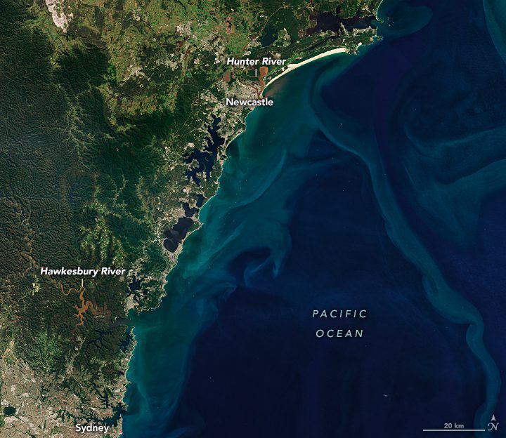
The ground was saturated and rivers were swollen when the Operational Land Imager-2 (OLI-2) on Landsat 9 acquired these images on April 4, 2022. The ongoing impacts of flooding can be seen in the muddy rivers, inundated land and sediment plumes draining from rivers along the coast.

Near the top of the image, north of Newcastle, a large lobe of brown floodwater has inundated the Hunter Wetlands. A plume of sediment also can be seen discharging from the mouth of the Hunter River and flowing along the beach in Worimi National Park. Sydney and its harbor can be seen at the bottom left of the image.

Image Credit: NASA Earth Observatory image by Joshua Stevens, using Landsat data from the U.S. Geological Survey