

Tuesday, January 21st, 2020
Japan Aerospace Exploration Agency (JAXA) announced that its Super Low Altitude Test Satellite “TSUBAME” (SLATS) was registered by the Guinness World Records as having achieved the “lowest altitude by an Earth observation satellite in orbit.” With its...
Tuesday, January 7th, 2020
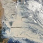
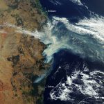
The record-setting and deadly fire season in Australia took a dramatic turn in the last week of December and first week of January. Residents of southeastern Australia told news media about the daytime seeming to turn to...
Monday, December 16th, 2019
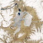
Karakul in many Turkish languages means “black lake.” That description of Karakul Lake, located high in the eastern Pamir Mountains in Tajikistan, is accurate for some of the year. But during the region’s frigid winter, the dark...
Tuesday, December 10th, 2019
India Observatory, the country’s first socio, economic, ecological open-source integrated geospatial data platform, was launched at Hyderabad during the GeoSmart India conference. The observatory contains comprehensive information on India’s social, ecological and economic parameters on a single...
Tuesday, December 3rd, 2019
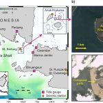
The deadly volcanic eruption of Anak Krakatoa in 2018 unleashed a wave at least 100 meters high that could have caused widespread devastation had it been travelling in another direction, new research shows. Over 400 people lost...

Monday, November 25th, 2019
As haze blanketed large tracts of Southeast Asia in October 2019, office workers with Genting Plantations Bhd. in Jakarta were investigating the source of the choking smoke more than a thousand kilometers away. Images collected from drones...
Tuesday, November 19th, 2019
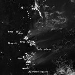
The Copernicus Sentinel-3 mission captured the multiple bushfires burning across Australia’s east coast. Around 150 fires are still burning in New South Wales and Queensland, with hot and dry conditions accompanied with strong winds, said to be...
Tuesday, November 12th, 2019
Bushfires are still raging in Australia, particularly along the east coast of New South Wales (NSW) and Queensland. The leader of the rural fire service told media that this could be “the most dangerous bushfire week this...
Tuesday, November 5th, 2019
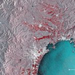
This image shows the extent of flooding on Japan’s main island of Honshu. Captured by the Copernicus Sentinel-1 mission, the image shows the floods in red around the cities of Sendai and Ishinomaki on Oct. 12, 2019....
Tuesday, October 29th, 2019
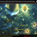
According to information obtained from the Indian Space Research Organisation (ISRO) Chandrayaan-2 Dual-Frequency Synthetic Aperture Radar (DF-SAR) satellite, the moon has been continuously bombarded by meteorites, asteroids and comets since its formation. This has resulted in the...
