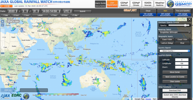
Tuesday, March 31st, 2020
Global Satellite Mapping of Precipitation (GSMaP) has been developed by using multi-satellite products. The rainfall map is provided in real time and visualized every 30 minutes on the JAXA Realtime Rainfall Watch website. Please have a look...
Tuesday, March 24th, 2020
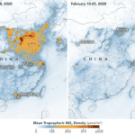
In countries and regions that have been under strict lockdowns to stop the spread of the coronavirus, an unintended consequence is visible from space. As businesses, industrial sites and factories closed, and cars and trucks stayed off...

Tuesday, March 17th, 2020
China’s first polar-observation satellite has completed its Antarctic observation mission after orbiting Earth for six months. Since it was launched on Sept. 12, 2019, the satellite called “Ice Pathfinder” (Code: BNU-1) has sent back more than 1,000...

Tuesday, March 10th, 2020
Crowd-sourcing map app Waze announced a new initiative in Malaysia as part of a partnership with Kuala Lumpur’s Tun Razak Exchange (TRX) to help drivers in the Malaysian capital “move better” and “stay safe.” Bluetooth-enabled devices—known simply...

Tuesday, March 3rd, 2020
More frequent and intense rainfall events due to climate change could cause more landslides in the High Mountain Asia region of China, Tibet and Nepal, according to the first quantitative study of the link between precipitation and...

Monday, February 24th, 2020
U.S. Naval Research Laboratory (NRL) physical scientists, engineers, and principal investigator Andrei Abelev visited Australia in May 2019 to validate their techniques for terrain characterization. Using multiple types of sensors to gain understanding of different soils, the...
Tuesday, February 18th, 2020
Using archives of satellite imaging data, a study in Frontiers in Earth Science has conducted the most in-depth study of China’s intertidal wetlands to date and found a 37.62% decrease in area between 1970 and 2015. Intertidal...

Tuesday, February 11th, 2020
On Feb. 6, 2020, a medical delivery drone flying from the people’s Hospital of Xinchang County to the disease control center of Xinchang County successfully completed the whole process of air transportation, marking the launch of the...
Tuesday, February 4th, 2020
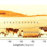
Bushfires have raged in Victoria and New South Wales since November 2019, yielding startling satellite images of smoke plumes streaming from southeastern Australia on a near daily basis. The images got even more eye-popping in January 2020...

Tuesday, January 28th, 2020
Japan Aerospace Exploration Agency (JAXA) agreed to collaborate with Food and Agriculture Organization of the United Nations (FAO) on data utilization of Earth-observation satellites. Imai Ryoichi (left), JAXA vice president, and Daniel Gustafson (right), FAO’s Deputy Director-General...
