

Friday, September 9th, 2011
If you have trouble viewing this, click here to view in a browser ASM Website Calendar Submit Editorial Mobility Tools Support Infrastructure DesignContinuous data gathering, exchange and update operations are setting the pace for investment and...

Thursday, September 8th, 2011
Singapore's Urban Redevelopment Authority (URA) has won the prestigious Exemplary Systems in Government (ESIG) award from the Urban and Regional Information Systems Association (URISA). The URA Digital 3D Urban Model System garnered praise because it was built...

Thursday, September 8th, 2011
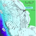
Monitoring and mapping of oceanographic currents helps in understanding the movement of contaminants in ocean waters and estimating the impacts of climate change and to provide faster sea ship routes. The Korea Hydrographic and Oceanographic Administration has recently...
Thursday, September 8th, 2011
Hyderabad-based Indian National Centre for Ocean Information Services (INCOIS) has started work on multi-hazard vulnerability mapping of the country's entire coastline. The mapping effort aims to inform authorities of vulnerable areas so that they can adequately prepare...

Friday, September 2nd, 2011
If you have trouble viewing this, click here to view in a browser ASM Website Calendar Submit Editorial Health Mapping Places Original Source of Cholera Pandemic to BangladeshResearchers have been working for some time to trace...

Thursday, September 1st, 2011
This week the Bureau of High-Speed Rail in Taiwan (HSR) decided to innovate railway transportation through providing 4G wireless internet. This is a clear sign that being connected, even while moving at high-speed, knows no bounds and...
Thursday, September 1st, 2011
The Education Services Australia (ESA) has launched Spatial Genie, an education system to promote GIS in Australian schools. This capability marks the first time the education system in Australia has invested in the development and promotion of...
Friday, August 26th, 2011
If you have trouble viewing this, click here to view in a browser ASM Website Calendar Submit Editorial Australian Carbon Farming Law - Need For Precision FarmingThe Australian government passed new laws to support carbon farming....
Wednesday, August 24th, 2011
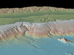
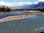
The source of the Brahmaputra, Indus, Salween and Irrawaddy rivers was reported this week from scientists at the Chinese Academy of Sciences (CAS). Using satellite imagery, Liu Shaochuang, a researcher with the Institute of Remote Sensing Applications at CAS reported...
Friday, August 19th, 2011
To date, tsunami detection and warning systems have been based on deep-water, pressure-sensor observations that determine changes in sea surface elevation and fluctuation on the coast, which are point measurements. Researchers observed after-the-fact that existing coastal current...
