
Tuesday, January 18th, 2011
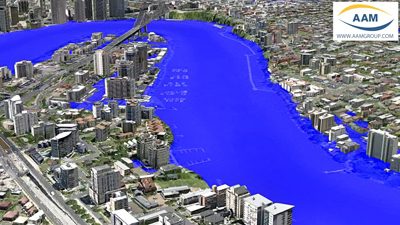
AAM’s 3D Flood Simulation of Brisbane was used extensively by Australian and Global media during the recent flood crisis in Brisbane. The flood level simulations were produced interactively in 3D. This was a very effective way of communicating...
Tuesday, January 18th, 2011
The Guangxi Zhuang autonomous region plans to increase its efforts to build a high-speed railway network providing another link with the 10-member Association of Southeast Asian Nations (ASEAN), which is the region's biggest trading partner and export...
Tuesday, January 18th, 2011
Topcon Positioning Systems (TPS) new RTP-300 Real Time Profiler collects surface data at speeds up to 65 miles per hour (105 km/hr) and creates an exact model of the existing surface.
Monday, January 17th, 2011
LPS is a powerful, workflow-oriented photogrammetry system for production mapping, including full analytical triangulation, the generation of digital terrain models, orthophoto production, mosaicking, and 3D feature extraction.
Monday, January 17th, 2011
Starting today, Esri software users can sign up to take the Esri Technical Certification Program examinations. The program recognizes people skilled in desktop, developer, and enterprise use of Esri technology. Certifications are currently being offered for:
Monday, January 17th, 2011
The Food Security Atlas is aimed to contribute to a better understanding of the spatial patterns of food security, poverty and malnutrition in Nepal inorder to provide a solid basis for developing a comprehensive national food security...
Monday, January 17th, 2011
Certification for GIS technician - GIS education program is to undergo certification to be granted points needed to become a senior technician. Educational programs, seminars and workshops, working people are eligible. for the program at Rissho University....
Monday, January 17th, 2011
We know that groundwater management is critical to India's water, food and livelihood security. Groundwater supports more than 55% of our irrigation requirements, 85% of domestic requirements in rural areas and over 50% of requirements in urban...
Monday, January 17th, 2011
Hong Kong's interesting rock formations and natural landforms are numerous and easily accessible. The Agriculture, Fisheries and Conservation Department has launched its iPhone app to showcase various Geo-tour Routes in Hong Kong National Geopark. It's a free...