Asian Surveying & Mapping
Breaking News
HAL to build, market Isro’s SSLV in landmark deal
New Delhi, Jun 20: In a historic move for...
Taiwan developing space capabilities for all-weather imaging
TAIPEI (TVBS News) — Taiwan is advancing its space...
Honda hails successful test of reusable rocket as it looks to get into the space business
Tokyo — Japan's second-biggest carmaker, Honda, has successfully tested...
China’s space program provides larger platform for broader international cooperation
BEIJING -- Experts from China's manned space program said...
India To Launch $1.5 Billion Joint Earth Mission With NASA In July
National Aeronautics and Space Administration (NASA) and the Indian...
Axiom-4 mission delayed again: ISRO confirms Subhanshu Shukla’s ISS spaceflight won’t launch before 22 June 2025
The Axiom-4 mission to the International Space Station has...
Mengzhou spacecraft for China’s moon-landing mission passes landmark test flight
China has completed the inaugural test flight of its...
Space application for ITMA Asia + CITME 2026 opens
Shanghai – Space application for the 2026 edition of...
Yanmar, Chia Tai and XAG Empower Thai Agriculture through Innovation
Bang Nam Priao District, Chachoengsao Province, Thailand – On...
bitsensing Signs MOU with IKIO Technologies to Advance AI-Based Traffic Monitoring on India’s Expressways, Highways and Municipal Areas
Backed by proven success in South Korea and Europe,...
AAM_Flood_Image_Simulated_6_small

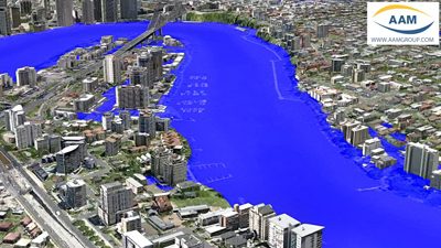
The flood simulations were featured extensively on Australian and International media. The videos supplied residents, business owners and the public with realistic representations of the predicted flood event.

The flood simulation was based on accurate geospatial terrain data created by AAM. AAM provides Engineers and Planners with photo realistic 3D City Models and highly accurate terrain models to aid in their assessment and design tasks.
AAM General Manager, Brian Nicholls, says that he hopes that AAM’s simulationshelp in some way to communicate the scale and extent of the flooding. “We hope that the recent events in Queensland will prompt greater consideration to be given to highresolution mapping, which can then be used to help manage future flood events in manyareas of Australia at risk.”
The videos are accessible on YouTube or the AAM Website. They continue to befeatured on Australian and International media.

Read More