Asian Surveying & Mapping
Breaking News
bitsensing Signs MOU with IKIO Technologies to Advance AI-Based Traffic Monitoring on India’s Expressways, Highways and Municipal Areas
Backed by proven success in South Korea and Europe,...
Nuri rocket successfully completes KAIST’s next-gen satellite mission
The Korea Advanced Institute of Science and Technology (KAIST)...
President Lai reviews progress on first indigenous satellite constellation
President Lai Ching-te said developing space technology is a...
Japan’s iQPS lines up eight SAR launches
ST. LOUIS — Japan’s Institute for Q-shu Pioneers of...
UAE Astronauts Promote AI and Collaboration in Space at GITEX Europe
The Arab world’s first astronaut, Hazzaa Al Mansouri, and...
New species of space-adapted bacteria discovered on China’s Tiangong space station
Scientists have discovered a previously unknown strain of microbe...
Isro’s 101st mission fails as PSLV-C61 suffers third-stage anomaly
India’s latest Earth observation satellite mission faced a setback...
Iraq’s First Fully Solar-Powered Village in Kulak Is Now Operational
ERBIL, Kurdistan Region – May 20, 2025 — The...
Australia’s Gilmour Space Technologies ready to launch maiden Eris Test flight the nation’s first orbital launch in over 50 years
Gilmour Space Technologies is the leading launch services company...
Korea’s space agency seeks revision of plan to modify next-gen rockets into reusable system
South Korea's aerospace agency said on Thursday that it...

Geospatial

image

Thursday, August 11th, 2011

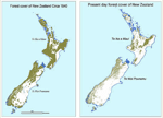
New Zealand Embarks on Four-Year, $4 Million Mapping Programme

The government of New Zealand has announced a research programme today to use satellite imagery and geospatial mapping to map forests, pastures, rivers and cities across the country. The four-year Land Cover Research Programme was launched with...

Monday, August 8th, 2011

Azerbaijan – Development Concept in Real Estate management

Baku will host the international scientific-practical conference "Role of national spatial data infrastructure and a unified cadastre of real estate in modern property management system" on October 6-7, 2011 under the Azerbaijani State Property Committee. The conference is...

Friday, August 5th, 2011

Australian Geophysical Survey Boundary Polygons Available

A file containing survey boundary outlines in MapInfo TAB format for surveys in WA (WAEIS Phase 2 magnetic and radiometric; Albany-Fraser, Sandstone and South Gascoyne Gravity), SA (Frome), NT (West Arunta Gravity) and NSW (SE Lachlan). Read...

Thursday, August 4th, 2011

APRSAF 18 Announced

We are pleased to announce that the eighteenth session of the Asia-Pacific Regional Space Agency
Forum (APRSAF-18) will be held from 6 to 9 December 2011 in Singapore. The APRSAF-18 will be jointly
organized by...

Thursday, July 28th, 2011

India Releases Atlas of Freedom Movement

An atlas, which traces historical events comprising the Freedom Movement of India in geo-spatial depiction, was released at the Geo Summit 2011, held at the Satyabhama University here. Prithvish Nag, Director, National Atlas & Thematic Mapping Organisation (NATMO),...

Tuesday, July 26th, 2011

What Does An Integrated Geospatial Strategy Mean?

From surveying to mapping to earth observation, technologies are continually changing. At the same time, regulations and laws are continually evolving. Meanwhile, financial budgets are fluctuating and the the demands of partners and the public are fluctuating....

Friday, July 22nd, 2011

CARIS Offers Port Engineering Solution in Latest Bathy DataBASE Release

CARIS has launched a new module as part of the release of Bathy DataBASE 3.2. The Engineering Analysis Module caters to the requirements of the dredging industry, port and waterway authorities, as well as other engineering operations.

...

Thursday, July 21st, 2011

Japan’s Zenrin May Buy 24% In GIS Firm MapMyIndia

Japanese map publisher Zenrin Co Ltd may acquire 24% stake for $30 Mn in CE Info Systems Pvt Ltd, which runs MapMyIndia.com, an online map service.  The deal will value MapMyIndia at $125 Mn. If the deal...

Wednesday, July 20th, 2011

Smart Grid – Balancing the Flow

The smart grid continues to develop in many countries. The benefits of the grid include improvements in balancing energy generation and distribution across large regions, greater understanding of energy needs and the ability to manage operations. As...

Tuesday, July 19th, 2011

New Chairman of the Global Geodetic Observing System GGOS

Mr. Prof. Dr.-Ing. Hansjörg Kutterer, president of the Federal Agency for Cartography and Geodesy (BKG), chairman of the Global Geodetic Observing System GGOS (Global Geodetic Observing System) has been appointed.

Page 14 of 23 1 9 10 11 12 13 14 15 16 17 18 19 23