A common question asked by many people in organisations and government today is, “what is the best geospatial strategy for us?” This is often followed by many descriptions about how an individual business is involved in solving spatially related problems and tackling business challenges.
The answer can be approached in many ways. From a business perspective, the immediate integrated challenges relate to a particular solution(s) being offered, and pursuing sustainable activity around them. A company offering transportation solutions, for example, would seek to integrate a chain of spatial data and solution capabilities that support transport objectives. An agricultural-based organisation on the other hand, might be interested in integrated earth observation data with precision farming operations and those solutions linking to them.
But would a transport oriented service necessarily be interested in a agricultural solution for farming? Probably not to a great degree. That being the case, a clear end to integration is readily identified.
But does this apply to other circumstances?
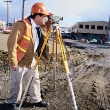
Consider the case of a surveying company that uses lidar, total stations, GNSS technology and geographic information systems (GIS) – all within their daily business practices. In one project they may be performing cadastral surveys, on another they may be performing roadbed alignment that includes cut-and-fill operations and GNSS enabled machinery – all within a 3D environment. In this case, the level of integration for spatial tools and data is wider, more integrated and crosses projects in a multi-disciplinary fashion.
As scale changes, the level of integration often changes. At local, regional and national levels, there are more participants and therefore more to integrate, as might be expected. Clear lines are not easily drawn and the use of spatial data may serve many users, companies and organisations – and for widely different purposes.
Shri Vilasrao Deshmukh, Union Minister for Science and Technology and Earth Sciences in India suggested recently, “every pure science research must have its end goal as service to mankind.” His immediate concern surrounded issues relating to monsoon prediction and the subsequent reduction of damage and loss of life.
But he also said, “another priority area of the Ministry he said Science Ministries will facilitate the building of joint projects with Indian research groups and global research community, both of Indian origin or otherwise, to address critical and priority issues so that advances of S & T can contribute to national development.”
That observation is of particular importance to the geospatial community because he is signalling that funding ought to follow two principles: 1) what is the related service to mankind and; 2) their benefits to national economic development.
Returning to questions relating to geospatial integration then, we might reasonably expect that any integration will necessarily involve these two principles.
Recently, the State of Spatial Data Infrastructures for Turkey were discussed. Authors Akın Kisa and Sedat Bakici suggested that work follows the principles of National Spatial Data Infrastructures, and said they are “defined as the “technologies, policies, and people necessary to promote sharing of geospatial data throughout all levels of government, the private and non-profit sectors, and the academic community.”
Under this description, integration is clear and identified. The sharing aspect ties to the comments of the Indian Minister earlier.
Christchurch City Council in New Zealand recently used gaming to discuss and collaborate about the future development of the City of Christchurch. The ‘Magnetic South‘ project involved online discussion by nearly one thousand people about the future, something that included a variety of integrated debates and the integration of thoughts.
It would seem apparent that geospatial integration involves spatial data, spatial tools, governance and collaboration of people. This combination readily shows that geospatial integration is not limited to tools, geodata or politics alone. Increasingly, individuals and governments are using high quality spatial data and geo-services to enable discussion, debate and support decisions.
A sound goal for the geospatial community is to support this combination, enabling members of society to engage, interact and exchange accurate, high quality information based on real data.
As this coupling of using geospatial data and debate circles and cycles, the seedlings of growth and design, leading toward new ways for implementing solutions and living will flourish.
