Asian Surveying & Mapping
Breaking News
Japan’s space agency to advance earthquake damage estimation programme
Tokyo: Japan’s Aerospace Exploration Agency (JAXA) has signed an...
Taiwan-made PARUS-T1 CubeSat launched into space orbit: Space agency
Taipei, Jan. 15 (CNA) A CubeSat designed and made...
China launches Earth observation satellite for Pakistan
HELSINKI — China launched the first satellite of a...
UAE space company launches earth-monitoring craft
Space42, a space technology company that has its headquarters...
ISRO successfully executes SpaDeX docking experiment; India joins elite club of nations
The Indian Space Research Organisation (ISRO) in the early...
APAC region gaining local access to ScanFish ROTV rental and support
Singapore 15 January 2025 With a rapid increase in...
Space42’s Thuraya 4 Satellite Successfully Launched Into Orbit
ABU DHABI, UAE and CAPE CANAVERAL, Fla. —   Space42 (ADX:...
SIIS Signs MOU with Pixxel to Introduce Hyperspectral Satellite Data in Korea
Seoul, South Korea; Jan. 7, 2025: SIIS Co., Ltd....
ISRO Launches Historic SpaDeX Mission for Space Docking
ISRO successfully launched the SpaDeX mission on December 30,...
Chinese firm deploys satellite-to-ground laser communications, outpacing Starlink
A Chinese firm has surpassed Starlink by deploying satellite-to-ground...
NZLandChange thumb

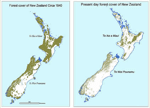
“The four-year Land Cover Research Programme will provide vital information about our rural and urban environment for the natural resources sector, regional councils and research organisations to use,” Smith said. “Using the best in modern technology, we can thoroughly map New Zealand’s changing land use so we can quantify the pressures on water quality and biodiversity.”

The Land Cover Research Programme will be led by Crown Research Institute Landcare Research, with the involvement of the Ministry for the Environment, the Department of Conservation, the Ministry of Agriculture & Forestry and regional councils. It will build on the Ministry for the Environment’s Land Use and Carbon Analysis System (LUCAS) developed to report New Zealand’s carbon emissions to the United Nations.

“Up-to-date information about vegetation, water sources and the built environment is critical for the success of natural resource industries such as agriculture and forestry,” said Mapp.