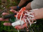

The researchers stop every 100 km to collect and catalog waste, including the tracking of barcodes found on litter in order to help determine where it was manufactured, packaged, sold, and transported to. Different beaches, no matter how remote, have contained different types of litter depending on their location, tides and currents.
Ultimately, the debris maps that are being produced will be matched with wildlife distribution patterns for marine species to produce risk maps that pinpoint the type of debris most dangerous to particular species. To date, a full third of the debris has been from the beverage industry with bottles, cans and straws a very common sight. A national database will be developed so that people can see all the data, and they will also be empowered to collect their own data.
The team have covered Melbourne, and are now traveling along the Victorian west coast to South Australia and then to WA.