Asian Surveying & Mapping
Breaking News
Australian Space Agency funds development of aerospace-grade GNSS receiver
The Australian Space Agency has funded the development of...
Continuity risks for Australian EO data access
A new report details the widespread use of Earth...
China launches new remote sensing satellite
JIUQUAN, April 15 (Xinhua) -- China on Monday launched...
7.4-Magnitude Earthquake Strikes Taiwan
A major, 7.4-magnitude earthquake struck the eastern coast of...
Tata Deploys Its Geospatial Satellite In Space on Space X’s Falcon 9 Rocket
THIRUVANANTHAPURAM: Tata Company launched India's first private commercial satellite...
Taiwan’s Formosat-8 Satellite Set for Launch by 2025
The Taiwan Space Agency has announced progress on the...
Iranian Scientists to Build Satellite Constellation for 2 Simultaneous Missions
The scientists at the knowledge-based company had previously succeeded...
China provides geospatial intel and other military support to Russia, US says
The US has warned its European allies that China...
Japanese lunar lander company ispace raises $53.5 million in stock sale
WASHINGTON — Japanese lunar lander developer has raised $53.5...
Esri and Prince Sultan University Advance GIS Education Through Strategic Partnership
Memorandum of Understanding with Institution Enhances GIS Curriculum and...

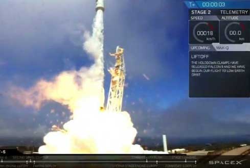
SpaceX successfully launched FORMOSAT-5, the first fully Taiwan-made Earth observation satellite, from Vandenberg Air Force Base in California on Aug. 24, 2017, nearly four years after its original intended late-2013 launch.

The 475-kilogram satellite was sent into a sun-synchronous, low-Earth orbit 720 kilometers above Earth, and the mission was declared a success after a ground station in Svalbard, Norway, received the first radio signals from FORMOSAT-5 to confirm its operational condition. Taiwan’s satellite will observe the Earth’s terrain and atmosphere for natural disaster management.

Click here for more information.

Photo Credit: SpaceX | Twitter