Asian Surveying & Mapping
Breaking News
South Korea is converting an abandoned coal mine into a moon exploration testing ground
South Korea is transforming abandoned coal mines into testing...
ISRO to Launch Chandrayaan-5 With Japan, Plans Space Station
Dr. V. Narayanan, Chairman of the Indian Space Research...
Russia and China are threatening SpaceX’s Starlink satellite constellation, new report finds
SpaceX's Starlink satellite constellation is facing threats from Russia...
China and Pakistan agree to fly 1st foreign astronaut to Chinese space station
For the first time, the Chinese space program will train...
ISRO’s “Space on Wheels” offers a peek into Indian Space Programme to students in Karimnagar
The Indian Space Research Organisation (ISRO)’s “Space on Wheels”...
Geospatial led solutions build the foundations for better decision-making
Geo Connect Asia 2025 paves the way for turning...
GEOSA, Singapore Land Authority Launch Achievements of Joint Geospatial System Project
Riyadh, SPA -- The General Authority for Survey and...
Building in Bangkok collapses as powerful earthquake hits southeast Asia
One person has died and 50 were injured in...
Bellatrix Aerospace Partners with Astroscale Japan for Space Debris Removal
Bellatrix Aerospace, a Bengaluru-based space mobility company, has joined...
NSTC announces Pingtung site as Taiwan’s space mission launch center
Taipei, March 26 (CNA) Taiwan's National Science and Technology...
philippines_flooding

The announcement was made at the same time that the government unveiled the flood-control project for the Agnos River. The new Agnos River Flood Forecasting and Warning system (FFWS) is a P243-million project that combines sensors and systems to monitor this flood-prone area, and was part of Japan International Cooperation Agency (JICA) project.

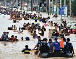
The Philippines are considered one of the world’s most vulnerable countries to natural disasters, sitting on the Pacific’s earthquake and volcano belt, and hit by an average of 20 typhoons a year. The low-lying islands are often devastated by floods.

The modern map of the country is meant to minimize destruction, saving lives and property. No details are yet available regarding the mapping methodology or timeline of the project.

Sources

Space Daily, Manilla Bulletin