Asian Surveying & Mapping
Breaking News
HAL to build, market Isro’s SSLV in landmark deal
New Delhi, Jun 20: In a historic move for...
Taiwan developing space capabilities for all-weather imaging
TAIPEI (TVBS News) — Taiwan is advancing its space...
Honda hails successful test of reusable rocket as it looks to get into the space business
Tokyo — Japan's second-biggest carmaker, Honda, has successfully tested...
China’s space program provides larger platform for broader international cooperation
BEIJING -- Experts from China's manned space program said...
India To Launch $1.5 Billion Joint Earth Mission With NASA In July
National Aeronautics and Space Administration (NASA) and the Indian...
Axiom-4 mission delayed again: ISRO confirms Subhanshu Shukla’s ISS spaceflight won’t launch before 22 June 2025
The Axiom-4 mission to the International Space Station has...
Mengzhou spacecraft for China’s moon-landing mission passes landmark test flight
China has completed the inaugural test flight of its...
Space application for ITMA Asia + CITME 2026 opens
Shanghai – Space application for the 2026 edition of...
Yanmar, Chia Tai and XAG Empower Thai Agriculture through Innovation
Bang Nam Priao District, Chachoengsao Province, Thailand – On...
bitsensing Signs MOU with IKIO Technologies to Advance AI-Based Traffic Monitoring on India’s Expressways, Highways and Municipal Areas
Backed by proven success in South Korea and Europe,...
razaksat

RazakSAT-2 will be run by the National Space Agency (ANGKASA) with a launch date expected in 2015. The new satellite will include updgrades to the hardware and software of the currently orbiting satellite that has captured more than 1,000 images to date.

The investment is said to improve the economic growth of the country, with job creation as well as application in vital industries such as agriculture, forestry, and fisheries. The satellite will also improve mapping and land use planning as well as coastal monitoring.

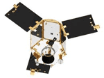
The existing RazakSAT satellite is the country’s second satellite after the original TiungSAT-1 that was launched in September 2000. RazakSAT carries a pushbroom camera with five linear detectors ( a panchromatic and four multi-spectral). The satellit achieved the intended Near-Equatorial Low Earth Orbit (NEqO) at 685 km altitude and a 9 degree inclination, giving it the ability to revisit the country every 90 minutes. The revisit rate is an important factor because the equatorial location means heavy cloud cover over the country.