Asian Surveying & Mapping
Breaking News
Ecolab and ITE partners to harness water management knowledge for Singapore data center engineers
SINGAPORE, 29 APRIL 2024 – Nalco Water, an Ecolab...
NASA releases satellite photos of Dubai and Abu Dhabi before and after record flooding
NASA released photos of parts of Dubai and Abu...
Singapore releases 10-year Geospatial Master Plan
Singapore has launched its new Geospatial Master Plan (2024–33),...
Japan announces plans to launch upgraded observation satellites on new flagship rocket’s 3rd flight
TOKYO (AP) — Japan’s space agency announced Friday a...
Tesla China partners with Baidu for maps to clear FSD hurdle
Amidst Elon Musk’s unannounced trip to Beijing, China this...
ESA opens ideas factory to boost space innovation in Austria
A centre to innovate the design and manufacture of...
Japan’s space agency sets June 30 as third launch date for H3 rocket
The Japan Aerospace Exploration Agency (JAXA) announced Friday that...
S. Korea launches nanosatellite for Earth observation
SEOUL- A South Korean nanosatellite was launched into orbit...
Australian Space Agency funds development of aerospace-grade GNSS receiver
The Australian Space Agency has funded the development of...
Continuity risks for Australian EO data access
A new report details the widespread use of Earth...
NZLandChange thumb

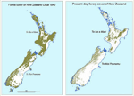
“The four-year Land Cover Research Programme will provide vital information about our rural and urban environment for the natural resources sector, regional councils and research organisations to use,” Smith said. “Using the best in modern technology, we can thoroughly map New Zealand’s changing land use so we can quantify the pressures on water quality and biodiversity.”

The Land Cover Research Programme will be led by Crown Research Institute Landcare Research, with the involvement of the Ministry for the Environment, the Department of Conservation, the Ministry of Agriculture & Forestry and regional councils. It will build on the Ministry for the Environment’s Land Use and Carbon Analysis System (LUCAS) developed to report New Zealand’s carbon emissions to the United Nations.

“Up-to-date information about vegetation, water sources and the built environment is critical for the success of natural resource industries such as agriculture and forestry,” said Mapp.