Asian Surveying & Mapping
Breaking News
South Korea is converting an abandoned coal mine into a moon exploration testing ground
South Korea is transforming abandoned coal mines into testing...
ISRO to Launch Chandrayaan-5 With Japan, Plans Space Station
Dr. V. Narayanan, Chairman of the Indian Space Research...
Russia and China are threatening SpaceX’s Starlink satellite constellation, new report finds
SpaceX's Starlink satellite constellation is facing threats from Russia...
China and Pakistan agree to fly 1st foreign astronaut to Chinese space station
For the first time, the Chinese space program will train...
ISRO’s “Space on Wheels” offers a peek into Indian Space Programme to students in Karimnagar
The Indian Space Research Organisation (ISRO)’s “Space on Wheels”...
Geospatial led solutions build the foundations for better decision-making
Geo Connect Asia 2025 paves the way for turning...
GEOSA, Singapore Land Authority Launch Achievements of Joint Geospatial System Project
Riyadh, SPA -- The General Authority for Survey and...
Building in Bangkok collapses as powerful earthquake hits southeast Asia
One person has died and 50 were injured in...
Bellatrix Aerospace Partners with Astroscale Japan for Space Debris Removal
Bellatrix Aerospace, a Bengaluru-based space mobility company, has joined...
NSTC announces Pingtung site as Taiwan’s space mission launch center
Taipei, March 26 (CNA) Taiwan's National Science and Technology...
oceanmapping

“With their unique ability for underwater flight and unprecedented range, speed and maneuverability, Hawkes DeepFlight submersibles make it easier and more cost effective to explore parts of the ocean that were previously out of reach — offering the potential to significantly expand scientific knowledge of the ocean that covers nearly three-fourths of the Earth’s surface,” indicated 4-Traders Online.

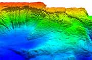
As Inventor of the Month, the company combines the best in design together with imagination. There are many geospatial and geomatic technologies that perform tasks and provide data above the ocean surface, but there are far fewer capable of monitoring, measuring and capturing real-time data in a similar way. 

Not that there are no technologies, but the ocean is vast and we already have evidence that it is difficult to continually monitor. Efforts involving tsunami measurements and monitoring, undersea volcanology and even locating all of the world’s ocean biodiversity continue to test our abilities (recently 67 new species have been found in ocean’s).

The design and development of spatial tools and technologies for oceanographic data capture will continue to grow. We should maintain a sense of inspiration, awe and curiosity about the oceans to the same extent that we do space. It would most certainly help to push us to innovate and invest more in ocean discovery and knowledge.