Asian Surveying & Mapping
Breaking News
HAL to build, market Isro’s SSLV in landmark deal
New Delhi, Jun 20: In a historic move for...
Taiwan developing space capabilities for all-weather imaging
TAIPEI (TVBS News) — Taiwan is advancing its space...
Honda hails successful test of reusable rocket as it looks to get into the space business
Tokyo — Japan's second-biggest carmaker, Honda, has successfully tested...
China’s space program provides larger platform for broader international cooperation
BEIJING -- Experts from China's manned space program said...
India To Launch $1.5 Billion Joint Earth Mission With NASA In July
National Aeronautics and Space Administration (NASA) and the Indian...
Axiom-4 mission delayed again: ISRO confirms Subhanshu Shukla’s ISS spaceflight won’t launch before 22 June 2025
The Axiom-4 mission to the International Space Station has...
Mengzhou spacecraft for China’s moon-landing mission passes landmark test flight
China has completed the inaugural test flight of its...
Space application for ITMA Asia + CITME 2026 opens
Shanghai – Space application for the 2026 edition of...
Yanmar, Chia Tai and XAG Empower Thai Agriculture through Innovation
Bang Nam Priao District, Chachoengsao Province, Thailand – On...
bitsensing Signs MOU with IKIO Technologies to Advance AI-Based Traffic Monitoring on India’s Expressways, Highways and Municipal Areas
Backed by proven success in South Korea and Europe,...

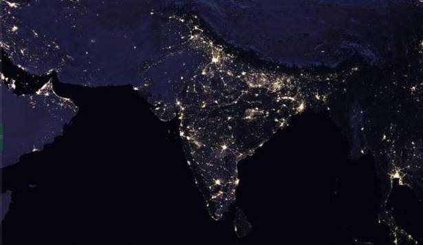
NASA recently released new global nighttime images of the Earth, including a detailed view of India and its surroundings that show how patterns of human settlement changed across the country between 2012 and 2016.

Satellite images of Earth at night—often referred to as “night lights”—have been a source of curiosity for the public and a tool for fundamental research for nearly 25 years, showing how humans shape the planet. Produced every decade or so, such maps have spawned hundreds of pop-culture uses and dozens of economic, social-science and environmental research projects.

In the years since the 2011 launch of the NASA-NOAA Suomi National Polar-orbiting Partnership (NPP) satellite, researchers have been analyzing night-lights data and developing new software and algorithms to make such imagery clearer, more accurate and readily available. They’re now on the verge of providing daily, high-definition views of Earth at night, and are targeting the release of such data to the science community later in 2017.

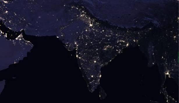
New NASA images compare the composite night-time view of India and its surrounding areas in 2016 (left) with that of 2012 (right). The images show how cities have grown and patterns of human settlements have changed across the country during those years. (Credit: NASA)