Asian Surveying & Mapping
Breaking News
Thailand to launch its second Earth satellite next week
Thailand is set to launch it second Earth observation...
Chinese launch startup’s rocket fails during satellite launch
The Chinese launch company Galactic Energy suffered its first...
First Hong Kong-made satellite set to launch in November from Guangdong province, company reveals
The first Hong Kong-made satellite is set to be...
China launches Yaogan 39 remote sensing satellite
China launched a Long March 2D carrier rocket on...
Saudi Arabia publishes maps with new names for ceded islands
A new map published by Saudi Arabia’s General Authority...
US, Saudi Arabia conclude region’s largest-ever counter-UAS exercise
The US and Saudi Arabia conducted the largest-ever counter-UAS exercise...
Study improves accuracy of planted forest locations in East Asia
An international team led by Purdue University scientists has...
Iran, Russia Working On Joint Research Spacecraft
In an interview with Tasnim, the president of the...
France, Bangladesh sign deal to provide loans, satellite technology during Macron’s visit to Dhaka
French President Emmanuel Macron witnessed the signature of a...
Iran, Russia Working on Joint Research Spacecraft
TEHRAN (Tasnim) – Top universities from Iran and Russia...
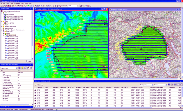
Leica_FPES10-2-Overview_flight_lines

Version 10.2 of Leica FPES provides enhanced planning features like graphical definition of the line direction or cutting groups of lines. The height range for elevation encoded color images can now be defined and Leica FPES v10.2 can also detect the minimum and maximum elevation in a DTM area, an AOI or in flight line footprints. New computation options allow to take the terrain height outside the AOI into account and coordinate systems of existing flight plans can be changed to merge flight plans together. Also many new QC features are implemented and the Flight Line Investigator is enhanced. Leica FPES v 10.2 frame flight plans can be exported now in the format for execution with Z/I Inflight.


Additionally Leica FPES v10.2 has incorporated a significantly enhanced AeroPlan for flight planning with Leica ALS sensors. The new AeroPlan70 provides graphical presentation of the computation results, includes one additional point density optimization method and the possibility to compute for multi-sensor configurations frame camera parameters that match the ALS settings. Furthermore, AeroPlan70 supports the recently announced Leica ALS70 airborne laser scanner.  

Availability

Leica FPES v10.2 is available immediately and ready for download for Customers of Leica FPES which are on Software Maintenance.