Asian Surveying & Mapping
Breaking News
HAL to build, market Isro’s SSLV in landmark deal
New Delhi, Jun 20: In a historic move for...
Taiwan developing space capabilities for all-weather imaging
TAIPEI (TVBS News) — Taiwan is advancing its space...
Honda hails successful test of reusable rocket as it looks to get into the space business
Tokyo — Japan's second-biggest carmaker, Honda, has successfully tested...
China’s space program provides larger platform for broader international cooperation
BEIJING -- Experts from China's manned space program said...
India To Launch $1.5 Billion Joint Earth Mission With NASA In July
National Aeronautics and Space Administration (NASA) and the Indian...
Axiom-4 mission delayed again: ISRO confirms Subhanshu Shukla’s ISS spaceflight won’t launch before 22 June 2025
The Axiom-4 mission to the International Space Station has...
Mengzhou spacecraft for China’s moon-landing mission passes landmark test flight
China has completed the inaugural test flight of its...
Space application for ITMA Asia + CITME 2026 opens
Shanghai – Space application for the 2026 edition of...
Yanmar, Chia Tai and XAG Empower Thai Agriculture through Innovation
Bang Nam Priao District, Chachoengsao Province, Thailand – On...
bitsensing Signs MOU with IKIO Technologies to Advance AI-Based Traffic Monitoring on India’s Expressways, Highways and Municipal Areas
Backed by proven success in South Korea and Europe,...

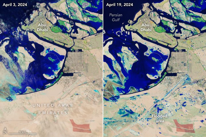
A slow-moving storm system pummeled the United Arab Emirates (UAE) and dropped more than a year’s worth of rain on some cities in April 2024. Heavy rain triggered flash flooding across eastern parts of the country, inundating roads and disrupting transportation.  

The system first hit Oman on April 14 and continued to batter the UAE through most of the day on April 16. Some areas remained flooded on April 19, when Landsat 9 passed over the region for the first time since the storms. The before and after images show flooding in Jebel Ali, a town 35 kilometers (22 miles) southwest of Dubai. The images are false color (bands 6-5-3) to emphasize the presence of water, which appears blue. Flooding can be seen in the industrial area of Jebel Ali just south of the port and near the green resorts and parks south of Palm Jebel Ali. 

Credit: NASA Earth Observatory images by Wanmei Liang, using Landsat data from the U.S. Geological Survey