Asian Surveying & Mapping
Breaking News
bitsensing Signs MOU with IKIO Technologies to Advance AI-Based Traffic Monitoring on India’s Expressways, Highways and Municipal Areas
Backed by proven success in South Korea and Europe,...
Nuri rocket successfully completes KAIST’s next-gen satellite mission
The Korea Advanced Institute of Science and Technology (KAIST)...
President Lai reviews progress on first indigenous satellite constellation
President Lai Ching-te said developing space technology is a...
Japan’s iQPS lines up eight SAR launches
ST. LOUIS — Japan’s Institute for Q-shu Pioneers of...
UAE Astronauts Promote AI and Collaboration in Space at GITEX Europe
The Arab world’s first astronaut, Hazzaa Al Mansouri, and...
New species of space-adapted bacteria discovered on China’s Tiangong space station
Scientists have discovered a previously unknown strain of microbe...
Isro’s 101st mission fails as PSLV-C61 suffers third-stage anomaly
India’s latest Earth observation satellite mission faced a setback...
Iraq’s First Fully Solar-Powered Village in Kulak Is Now Operational
ERBIL, Kurdistan Region – May 20, 2025 — The...
Australia’s Gilmour Space Technologies ready to launch maiden Eris Test flight the nation’s first orbital launch in over 50 years
Gilmour Space Technologies is the leading launch services company...
Korea’s space agency seeks revision of plan to modify next-gen rockets into reusable system
South Korea's aerospace agency said on Thursday that it...

The Japan Aerospace Exploration Agency (JAXA), along with the University of Aizu and Ritsumeikan University, released images captured by the Multi-Band Camera (MBC) onboard the Smart Lander for Investigating Moon (SLIM). 

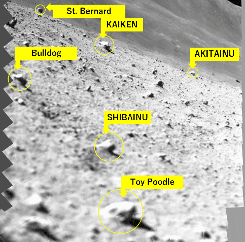
After the moon landing and before shutting down of the spacecraft power, MBC released the locking mechanism to withstand the impact upon launch and landing, then conducted scanning operations. The scanning is performed by moving the adjustable mirror and is for preliminary examination of the rocks of scientific interest that are situated around the SLIM landing site. The accompanying figure shows a landscape image created by synthesizing 257 low-resolution monochrome pictures. Based on this landscape image, the team is sorting out rocks of interest, assigning a nickname to each of them, with intent of communicating their relative sizes smoothly by the names. Preparation is underway to promptly conduct 10-band high-resolution spectroscopic observations once the solar illumination condition improves and SLIM recovers by the power generated by the solar array. 

Image Credit: JAXA, RITSUMEIKAN UNIVERSITY, THE UNIVERSITY OF AIZU