Asian Surveying & Mapping
Breaking News
Australian Space Agency funds development of aerospace-grade GNSS receiver
The Australian Space Agency has funded the development of...
Continuity risks for Australian EO data access
A new report details the widespread use of Earth...
China launches new remote sensing satellite
JIUQUAN, April 15 (Xinhua) -- China on Monday launched...
7.4-Magnitude Earthquake Strikes Taiwan
A major, 7.4-magnitude earthquake struck the eastern coast of...
Tata Deploys Its Geospatial Satellite In Space on Space X’s Falcon 9 Rocket
THIRUVANANTHAPURAM: Tata Company launched India's first private commercial satellite...
Taiwan’s Formosat-8 Satellite Set for Launch by 2025
The Taiwan Space Agency has announced progress on the...
Iranian Scientists to Build Satellite Constellation for 2 Simultaneous Missions
The scientists at the knowledge-based company had previously succeeded...
China provides geospatial intel and other military support to Russia, US says
The US has warned its European allies that China...
Japanese lunar lander company ispace raises $53.5 million in stock sale
WASHINGTON — Japanese lunar lander developer has raised $53.5...
Esri and Prince Sultan University Advance GIS Education Through Strategic Partnership
Memorandum of Understanding with Institution Enhances GIS Curriculum and...

In September and October 2023, Afghanistan and Morocco were hit by strong earthquakes. In Morocco, where such phenomena are quite uncommon, and in Afghanistan, they wiped out entire villages, killing thousands of people. Using satellite data, Dr. Laurynas Jukna and Elzė Buslavičiūtė, geographers at the Institute of Geosciences of Vilnius University (VU), revealed the actual magnitude of these earthquakes and explained how they can be tracked by employing modern satellite technology.  

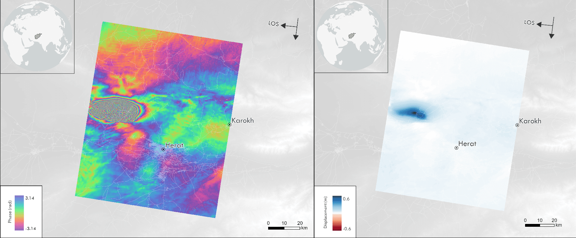
The Herat Province is located close to the junction of the Arabian, Indian and Eurasian plates, which means that earthquakes are quite common in this region. In western and central Afghanistan, it’s the northward movement of the Arabian Plate that has the greatest impact. On Oct. 8, 2023, the morning after the earthquake, the Sentinel-1 satellite data was made available for this area. The images showed the deformation of the surface between Sept. 26, 2023 and Oct. 8, 2023. The sequence of colors from blue to purple points to a ~3 centimeters deformation in the satellite LOS direction. The darker the color, the more severe the deformation; thus, we can see the densification of these fringes near the epicentre. In the blue area, the maximum deformation close to the epicenter reaches 60 centimeters in the satellite LOS direction.