Asian Surveying & Mapping
Breaking News
South Korea is converting an abandoned coal mine into a moon exploration testing ground
South Korea is transforming abandoned coal mines into testing...
ISRO to Launch Chandrayaan-5 With Japan, Plans Space Station
Dr. V. Narayanan, Chairman of the Indian Space Research...
Russia and China are threatening SpaceX’s Starlink satellite constellation, new report finds
SpaceX's Starlink satellite constellation is facing threats from Russia...
China and Pakistan agree to fly 1st foreign astronaut to Chinese space station
For the first time, the Chinese space program will train...
ISRO’s “Space on Wheels” offers a peek into Indian Space Programme to students in Karimnagar
The Indian Space Research Organisation (ISRO)’s “Space on Wheels”...
Geospatial led solutions build the foundations for better decision-making
Geo Connect Asia 2025 paves the way for turning...
GEOSA, Singapore Land Authority Launch Achievements of Joint Geospatial System Project
Riyadh, SPA -- The General Authority for Survey and...
Building in Bangkok collapses as powerful earthquake hits southeast Asia
One person has died and 50 were injured in...
Bellatrix Aerospace Partners with Astroscale Japan for Space Debris Removal
Bellatrix Aerospace, a Bengaluru-based space mobility company, has joined...
NSTC announces Pingtung site as Taiwan’s space mission launch center
Taipei, March 26 (CNA) Taiwan's National Science and Technology...

January 17th, 2023
Kilauea Erupts Again

image

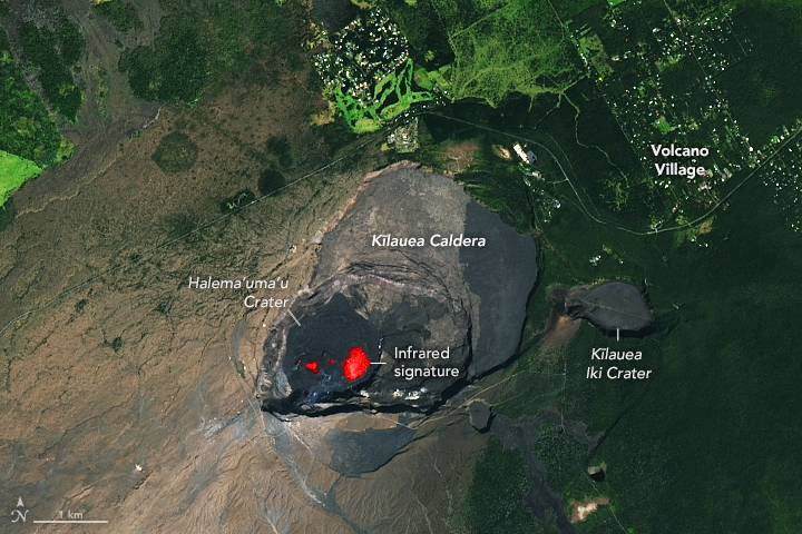
On Jan. 5, 2023, Kilauea—Hawaii’s youngest and most active volcano—began erupting once again. Scientists at the U.S. Geological Survey’s Hawaiian Volcano Observatory saw a glow in summit webcam images indicating that the eruption had resumed. They detected fissures at the base of Halema‘uma‘u crater, within the summit caldera, which generated lava flows. 

Multiple fountains of lava became active in Halema‘uma‘u crater on the afternoon of January 5. One large burst of lava reached 50 meters (164 feet) high and covered the crater floor with lava. By evening, lava had spilled across the crater at depths of about 10 meters (32 feet). 

The Operational Land Imager (OLI) on Landsat 8 acquired this image on Jan. 11, 2023.

Image Credit: NASA Earth Observatory image by Lauren Dauphin, using Landsat data from the U.S. Geological Survey.