Asian Surveying & Mapping
Breaking News
Intermap Announces $1 Million Program in Malaysia and Business Updates
DENVER – Intermap Technologies (TSX: IMP; OTCQB: ITMSF) (“Intermap” or...
From Kuala Lumpur To Singapore: Malaysia’s High-Speed Rail Resurgence Sparks China’s Pan-Asia Vision
The Malaysian government is once again working on building...
Japan’s Synspective successfully launches fourth SAR satellite
Synspective, the Japanese provider of Satellite/Synthetic Aperture Radar (SAR)...
South Korea’s Joowon Industrial Selects Aeva 4D LiDAR for Automated Power Line Inspection Program
MOUNTAIN VIEW, Calif. & SEONGNAM CITY, South Korea- Aeva®...
Synspective’s SAR Satellite, StriX-3, Successfully Reaches Its Target Orbit and Spreads Its Wings
TOKYO, 2024, March 13 – Synspective Inc., a SAR...
Indian Prime Minister Narendra Modi Commissions Genesys Digital Twin Map Stack in His Parliamentary Constituency
Mumbai: The Prime Minister of India, Mr. Narendra Modi, recently...
Geo Connect Asia 2024 to unveil geospatial’s transformative power
Geo Connect Asia (GCA) is set to return to...
Iran launches ‘domestically developed’ imaging satellite from Russia
The launch of Pars 1 is fourth this year,...
Astranis relocating hobbled debut satellite from Alaska to Asia
TAMPA, Fla. — Astranis is moving its debut satellite...
Asia space race heats up as China, Japan and India reach for the stars
After another year of US aeronautics company SpaceX dominating...

Despite China’s large land area, only one impact crater—the relatively small Xiuyan crater in Liaoning province—had been discovered there prior to 2020. Then, last year, a team of geologists found another crater northwest of Yilan in Heilongjiang Province. The crater was discovered in the heavily forested Lesser Xing’an mountain range, where local residents knew it as “Quanshan,” or “circular mountain ridge.”

The Yilan crater, slightly larger than Xiuyan, spans about 1.85 kilometers (1.15 miles), making it the largest crater on Earth under 100,000 years old. Carbon-14 dating of charcoal and organic lake sediments suggests the crater formed between 46,000 and 53,000 years ago. Meteor (or Barringer) Crater in Arizona is also roughly 50,000 years old, but its diameter is 1.2 kilometers (0.75 miles).

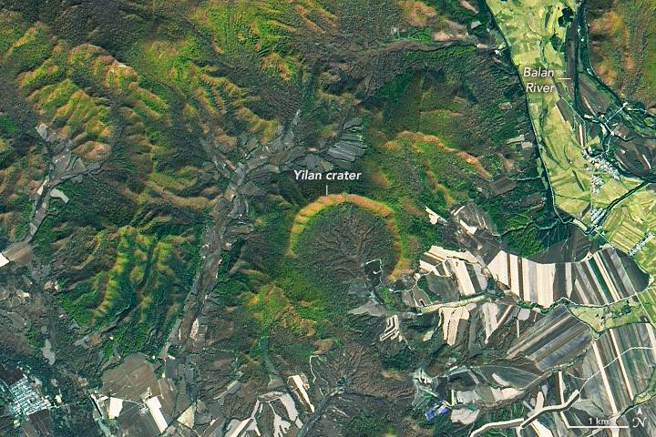
In the accompanying image, acquired by the Operational Land Imager (OLI) on Landsat 8 on Oct. 8, 2021, the scalloped northern rim of Yilan crater is highlighted by fall foliage. The northern rim—which rises 150 meters (500 feet) above the crater floor—is well-preserved, but the southern third of the crater rim is missing.

Image Credit: NASA Earth Observatory image by Lauren Dauphin, using Landsat data from the U.S. Geological Survey)