Asian Surveying & Mapping
Breaking News
Australian Space Agency funds development of aerospace-grade GNSS receiver
The Australian Space Agency has funded the development of...
Continuity risks for Australian EO data access
A new report details the widespread use of Earth...
China launches new remote sensing satellite
JIUQUAN, April 15 (Xinhua) -- China on Monday launched...
7.4-Magnitude Earthquake Strikes Taiwan
A major, 7.4-magnitude earthquake struck the eastern coast of...
Tata Deploys Its Geospatial Satellite In Space on Space X’s Falcon 9 Rocket
THIRUVANANTHAPURAM: Tata Company launched India's first private commercial satellite...
Taiwan’s Formosat-8 Satellite Set for Launch by 2025
The Taiwan Space Agency has announced progress on the...
Iranian Scientists to Build Satellite Constellation for 2 Simultaneous Missions
The scientists at the knowledge-based company had previously succeeded...
China provides geospatial intel and other military support to Russia, US says
The US has warned its European allies that China...
Japanese lunar lander company ispace raises $53.5 million in stock sale
WASHINGTON — Japanese lunar lander developer has raised $53.5...
Esri and Prince Sultan University Advance GIS Education Through Strategic Partnership
Memorandum of Understanding with Institution Enhances GIS Curriculum and...

The cataclysmic explosion of the Hunga Tonga-Hunga Ha‘apai volcano in January 2022 is reported to have been the biggest eruption recorded anywhere on the planet in 30 years. It sent a plume of ash soaring into the sky, left the island nation of Tonga smothered in ash, sonic booms were heard as far away as Alaska, and tsunami waves raced across the Pacific Ocean.

While the Tonga eruption was powerful but short, last year’s eruption of the Cumbre Vieja volcano on the Spanish Canary Island of La Palma was less explosive but lasted for almost three months.

Although different, both of these recent eruptions remind us all of how devastating nature can be. A better understanding of the natural processes that are occurring deep below our feet might bring the possibility of predicting eruptions a little closer.

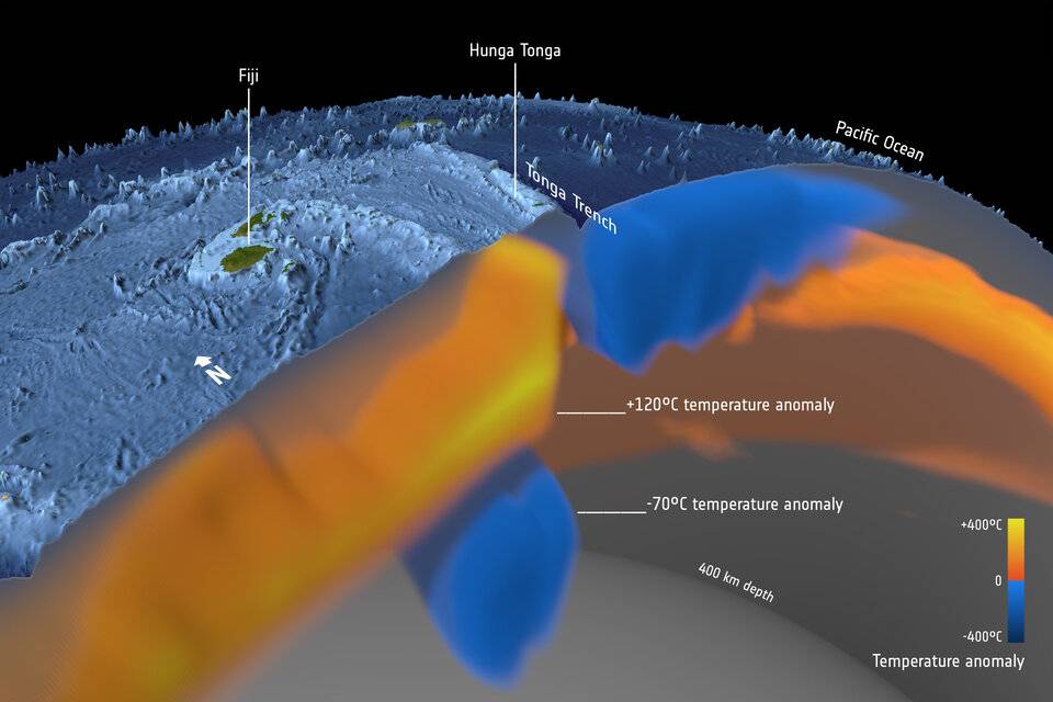
The Hunga Tonga-Hunga Ha‘apai volcano is located in a back arc basin, created by the subduction of the Tonga slab. Back arc volcanoes are associated with the cold slab being melted by the mantle as the slab slides down into the mantle. It is a part of the Tonga–Kermadec arc, where the edge of the Pacific tectonic plate dives beneath the Australian Plate. In this image, seismic tomography shows the layer of hydrated, partially molten rock above the plunging Pacific Plate, which feeds the volcanoes of the arc. (Credit: ESA/Planetary Visions)

Click here to read more.