Asian Surveying & Mapping
Breaking News
Japan Eyes Sovereign D2D Satellite Network
Japan plans to select a proposal this month for...
China schedules Long March 10B rocket launch and recovery attempt
HELSINKI — China is set for a debut flight...
BRICS space agencies meet begins in Bengaluru
Heads and senior representatives of the space agencies of...
“India’s growing space ecosystem to drive global collaboration”, says ISRO Chairman V Narayanan after BRICS Space Agencies Meeting
"India's growing space ecosystem to drive global collaboration", says...
UAE aims to see Emirati on Moon in next 10 years, says MBRSC chief
UAE expects to have a presence on the Moon within...
Safran, SatSure partner to develop geospatial intelligence solutions for India
French aerospace giant Safran Electronics & Defense and Indian...
Singapore unveils road map to help develop international business standards and conformance
Singapore has unveiled plans to help develop international standards...
Adelaide University to run space and defence venture launchpad ahead of Australian Space Forum
Adelaide University’s Innovation & Collaboration Centre (ICC) will deliver...
Japan’s H3 rocket returns to space with successful launch after December setback
Japan’s flagship H3 rocket has returned to flight six...
KONGSBERG accelerates seabed mapping developments with Ocean Exploration Trust expedition aboard Exploration Vessel Nautilus
KONGSBERG and the Ocean Exploration Trust (OET) are set...

June 10th, 2021
Singapore Deploys Drones to Monitor Reservoir Water Quality

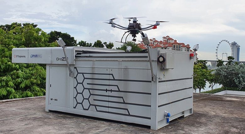
Singapore’s national water agency PUB is deploying autonomous drones at six of the country’s reservoirs to monitor water quality and other activities following trials in 2020.

The Beyond Visual Line of Sight (BVLOS) drones, which can be monitored remotely, are fitted with remote-sensing systems and cameras that can analyze water for turbidity and algae concentration—indicators of water quality—as well as look out for signs of aquatic plant overgrowth.

With some of Singapore’s reservoirs being used for recreational activities such as kayaking and fishing, the drones can also use video analytics to flag concerns, such as anglers fishing in non-designated areas or overcrowding of vessels.

Click here for more information.