Asian Surveying & Mapping
Breaking News
Safran, SatSure partner to develop geospatial intelligence solutions for India
French aerospace giant Safran Electronics & Defense and Indian...
Singapore unveils road map to help develop international business standards and conformance
Singapore has unveiled plans to help develop international standards...
Adelaide University to run space and defence venture launchpad ahead of Australian Space Forum
Adelaide University’s Innovation & Collaboration Centre (ICC) will deliver...
Japan’s H3 rocket returns to space with successful launch after December setback
Japan’s flagship H3 rocket has returned to flight six...
KONGSBERG accelerates seabed mapping developments with Ocean Exploration Trust expedition aboard Exploration Vessel Nautilus
KONGSBERG and the Ocean Exploration Trust (OET) are set...
Russian satellites linked to mysterious GPS disruptions across several countries
Since 2019, GPS signals across Europe, Greenland and Canada...
Isro’s Bahubali LVM3 that launched Chandrayaan-3 to be handed to private sector
IN-SPACe has invited Indian companies to take over the...
India to host 13th UN Global Geospatial Information Management Asia-Pacific Conference
India is hosting the 13th United Nations Global Geospatial...
Unseenlabs’ BRO-22 to Become the First Foreign Private Satellite Launched Aboard Japan’s H3 Launch Vehicle
Scheduled for June 10, between 09:53 and 11:52 a.m....
PLD Space increases investment in its Launch Complex at the Guiana Space Centre (CSG) to €35M, strengthening Europe’s sovereign space infrastructure
The investment is expected to generate approximately €21 million...

September 28th, 2020
Kiribati Under Siege from Rising Water Levels

The Republic of Kiribati is an independent island nation consisting of some 33 atolls near the equator in the central Pacific. The islands are spread over approximately 3.5 million square kilometers of ocean, but with a total land area of only 800 square kilometers.

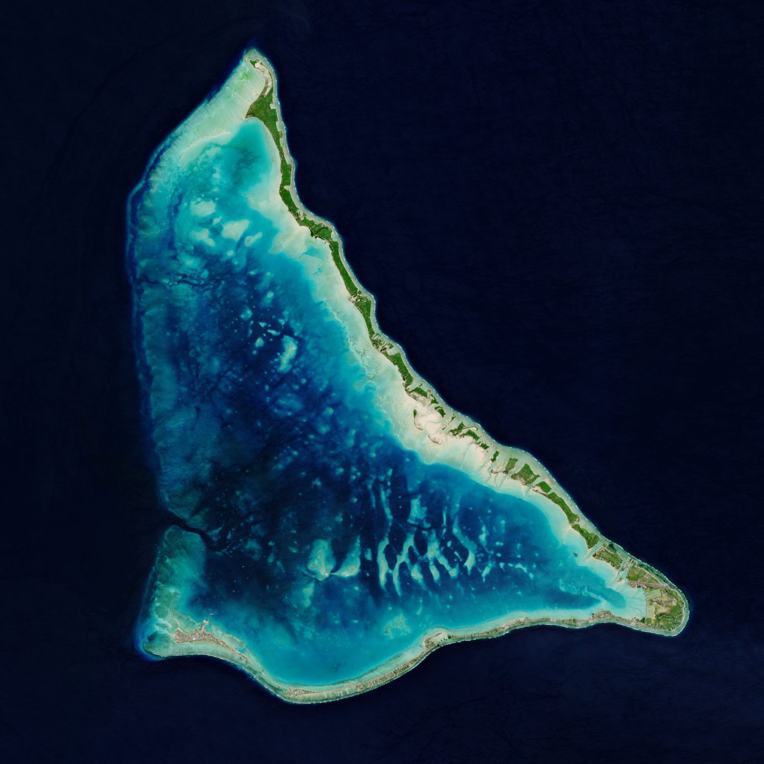
Tarawa Atoll, pictured here in a Copernicus Sentinel-2 image, lies approximately halfway between Hawaii and Australia. Tarawa consists of a large lagoon fringed by a V-shaped reef, around 35 kilometers long, and is made up of more than 30 islets. Tarawa, the site of a brutal World War II battle, is divided into North and South Tarawa.

South Tarawa is made up of a thin string of islets joined by causeways and is home to more than half of Kiribati’s 100,000 citizens. Bonriki International Airport serves as the main gateway to the country and can be seen in the bottom right of the image.

Kiribati is one of the lowest-lying nations in the world, with many of the country’s atolls and coral islands rising no higher than 2 meters above sea level, making them extremely vulnerable to sea-level rise. Kiribati has already seen growing damage from storms and flooding. In 1999, two of the nation’s unpopulated islets, Tebua Tarawa and Abanuea, disappeared underwater entirely.

Image Credit: Contains modified Copernicus Sentinel data (2020), processed by ESA.