Asian Surveying & Mapping
Breaking News
Australia and UK tie up for navigation without GNSS
Airborne navigation without GNSS is the aim of a...
Market size, technical gaps threaten Taiwan’s space dream
As global players like SpaceX dominate headlines, Taiwan is...
China quietly tested its first inflatable space module in orbit
BREMEN, Germany — China tested out a small expandable...
Isro Signs Agreement with Australian Space Agency for Gaganyaan Mission
Isro Signs Agreement with Australian Space Agency for Gaganyaan...
ESA and Japan expand collaboration in space exploration
The European Space Agency (ESA) and the Japan Aerospace...
Korea’s space development to hit wall without private sector initiative
The private sector should take the initiative in South...
India’s Chandrayaan-2 moon orbiter avoids collision with South Korea’s Danuri spacecraft
India's Chandrayaan-2 moon orbiter maneuvered in September to avoid...
Dubai residents may soon have opportunity to travel to the edge of space
Residents of Dubai may soon have the chance to...
Swift Navigation and KDDI Launch Skylark Precise Positioning Service Across Japan
SAN FRANCISCO and TOKYO - Swift Navigation, a global...
Thailand plays host to Southeast Asia’s largest space technology event
Thailand Space Week 2024, the region’s premier international space...

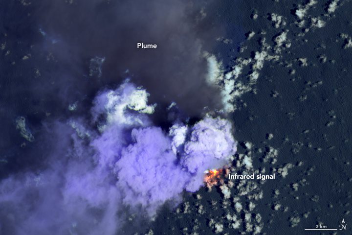
A young volcanic island has been growing in the western Pacific Ocean since 2013. Since mid-June 2020, it has been going through a vigorous growth spurt. Images show some of the latest eruptive activity at Nishinoshima, a volcanic island about 1,000 kilometers (600 miles) south of Tokyo. 

This false-color image, acquired by Landsat 8 on July 4, 2020, combines shortwave infrared and visible wavelengths (bands 7-6-4). It reveals the heat signature of erupting lava and the relative coolness of the dark ash plume (blowing north). The bright purple clouds close to the island could be steam from the volcano or from lava vaporizing seawater.

Image Credit: NASA Earth Observatory image by Lauren Dauphin, using MODIS data from NASA EOSDIS/LANCE and GIBS/Worldview.