Asian Surveying & Mapping
Breaking News
Chinese launch startup’s rocket fails during satellite launch
The Chinese launch company Galactic Energy suffered its first...
First Hong Kong-made satellite set to launch in November from Guangdong province, company reveals
The first Hong Kong-made satellite is set to be...
China launches Yaogan 39 remote sensing satellite
China launched a Long March 2D carrier rocket on...
Saudi Arabia publishes maps with new names for ceded islands
A new map published by Saudi Arabia’s General Authority...
US, Saudi Arabia conclude region’s largest-ever counter-UAS exercise
The US and Saudi Arabia conducted the largest-ever counter-UAS exercise...
Study improves accuracy of planted forest locations in East Asia
An international team led by Purdue University scientists has...
Iran, Russia Working On Joint Research Spacecraft
In an interview with Tasnim, the president of the...
France, Bangladesh sign deal to provide loans, satellite technology during Macron’s visit to Dhaka
French President Emmanuel Macron witnessed the signature of a...
Iran, Russia Working on Joint Research Spacecraft
TEHRAN (Tasnim) – Top universities from Iran and Russia...
India, Vietnam, Malaysia, Philippines and Taiwan reject China’s new ‘controversial’ map, release statements
China continues to receive brute criticism from countries that...
  • Jul 2, 2019
  • Comments Off on Chinese Satellites HY-1C and HY-2B to Monitor Sea and Environment
  • Feature
  • 1061 Views

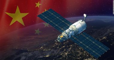
Chinese Ministry of Natural Resources has unveiled the details of the two sea-observing satellites HY-1C and HY-2B, which were launched in 2018 after they reached their designated orbit.

The HY-1C and HY-2B are the highest level of remote-sensing satellites, said Chinese Deputy Minister of Natural Resources Ling Yueming, adding that China will benefit from the two satellites in both land and sea monitoring, through the establishment of a resource monitoring network which will support environmental protection, stressing the encouragement of his country to exchange satellite data for the service of environmental protection, transport and agriculture as well as other industries.

Click here for more information.