Asian Surveying & Mapping
Breaking News
Space42’s Thuraya 4 Satellite Successfully Launched Into Orbit
ABU DHABI, UAE and CAPE CANAVERAL, Fla. —   Space42 (ADX:...
SIIS Signs MOU with Pixxel to Introduce Hyperspectral Satellite Data in Korea
Seoul, South Korea; Jan. 7, 2025: SIIS Co., Ltd....
ISRO Launches Historic SpaDeX Mission for Space Docking
ISRO successfully launched the SpaDeX mission on December 30,...
Chinese firm deploys satellite-to-ground laser communications, outpacing Starlink
A Chinese firm has surpassed Starlink by deploying satellite-to-ground...
SpaceX’s First Launch In 2025 To Be For UAE-Based Space Tech Company
Elon Musk’s rocket manufacturing company SpaceX is eyeing launching into space for...
ISRO PSLV-C60 SpaDeX Mission LIVE: India All Set For Gamechanger Launch, Countdown Begins
ISRO is set to launch PSLV-C60 with SpaDeX tonight...
Japan’s space agency delays satellite launch on new H3 rocket due to weather
Japan’s space agency has said its planned launch of...
Chinese company completes ultra-high-speed remote sensing image laser transmission test
BEIJING,- A commercial Chinese satellite company has conducted an...
Space42 and ICEYE Announce Joint Venture to Bring Satellite Manufacturing to the UAE
ABU DHABI, UAE —  Space42 (ADX: SPACE42), a UAE-based...
Australia and UK tie up for navigation without GNSS
Airborne navigation without GNSS is the aim of a...

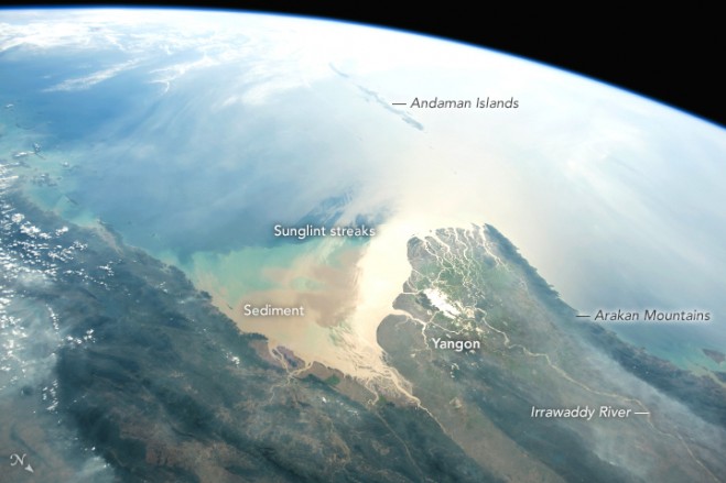
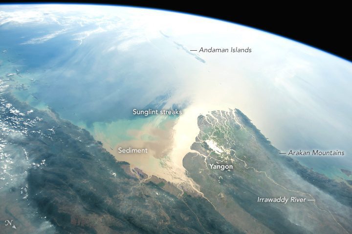
Using a short lens to give a wide view, an astronaut aboard the International Space Station (ISS) focused a camera on the 160-kilometer-wide Irrawaddy river delta. The Irrawaddy is the largest river in Burma (Myanmar) and the country’s most-important transportation artery. The capital city and port of Yangon is situated near the sea in a protected location on a major distributary.

The very bright zone near the coast is the sunglint point, where sunlight is reflected directly back at the camera. Astronauts frequently use a technique of following the glint point because it strongly emphasizes the details of shorelines.

The Irrawaddy River empties into the Andaman Sea, bringing vast quantities of silt and mud that alter the color of the water near the delta. In this photo, the sediment color pattern is complicated by bright and dark sunglint streaks caused by wind. On this day, westerly winds swept around the southern tip of the Arakan Mountains. (Note that north is to the bottom right of this photo.)

The chain of the Andaman Islands forms a line with the Nicobar Islands (under clouds, top left) along the tectonic margin between the Indian Plate and the Burma Plate. The Andaman Islands experienced a major earthquake of magnitude 9.0 in December 2004.

Image Credit: NASA