Asian Surveying & Mapping
Breaking News
South Korea is converting an abandoned coal mine into a moon exploration testing ground
South Korea is transforming abandoned coal mines into testing...
ISRO to Launch Chandrayaan-5 With Japan, Plans Space Station
Dr. V. Narayanan, Chairman of the Indian Space Research...
Russia and China are threatening SpaceX’s Starlink satellite constellation, new report finds
SpaceX's Starlink satellite constellation is facing threats from Russia...
China and Pakistan agree to fly 1st foreign astronaut to Chinese space station
For the first time, the Chinese space program will train...
ISRO’s “Space on Wheels” offers a peek into Indian Space Programme to students in Karimnagar
The Indian Space Research Organisation (ISRO)’s “Space on Wheels”...
Geospatial led solutions build the foundations for better decision-making
Geo Connect Asia 2025 paves the way for turning...
GEOSA, Singapore Land Authority Launch Achievements of Joint Geospatial System Project
Riyadh, SPA -- The General Authority for Survey and...
Building in Bangkok collapses as powerful earthquake hits southeast Asia
One person has died and 50 were injured in...
Bellatrix Aerospace Partners with Astroscale Japan for Space Debris Removal
Bellatrix Aerospace, a Bengaluru-based space mobility company, has joined...
NSTC announces Pingtung site as Taiwan’s space mission launch center
Taipei, March 26 (CNA) Taiwan's National Science and Technology...

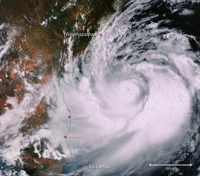
This Copernicus Sentinel-3 image captured on May 1, 2019, shows Cyclone Fani. Brewed in the Bay of Bengal and heading westwards, the cyclone was expected to make landfall on India’s east coast on May 3.

With wind speeds of up to 200 kilometers per hour, heavy rainfall and flooding have been forecast along the Odisha coast, and has led to the evacuation of around 800,000 people from the nearby low-lying areas.

In the image, the width of the storm is estimated to be around 700-800 kilometers. Once Cyclone Fani makes landfall, it is expected to move northeast, hitting Bangladesh and Bhutan on May 4.

Image credit: Contains modified Copernicus Sentinel data (2019), processed by ESA