Asian Surveying & Mapping
Breaking News
South Korea partially suspends inter-Korean agreement over North’s spy satellite
SEOUL, South Korea -- South Korea said North Korea fired...
Chinese software firm inks deal with Kenya to boost geospatial technology cooperation
Chinese technology firm, Supermap International, signed an agreement with...
Survey of India, Genesys International Sign MoU to Develop ‘Digital Twins’ Of Indian Cities
Genesys International, India’s home-grown geospatial mapping company and Survey...
UAE Space Agency leads first Space Pavilion participation at COP28
DUBAI - The UAE Space Agency is leading the...
ISRO, NASA likely to launch remote sensing satellite in 1st half of ’24
NEW DELHI: If everything goes as per plan, India...
IBM Advances Geospatial AI to Address Climate Challenges
YORKTOWN HEIGHTS, N.Y.- IBM (NYSE: IBM) today announced new...
Australia Greenlights Game-Changing Era: Commercial Drones with ParaZero Safety Systems to Fly
ParaZero is thrilled to be at the forefront of...
Asia’s top satellite operator aims to launch solar energy forecast system in Europe
Japan’s satellite titan SKY Perfect JSAT aims to expand...
Japan to set up $6.7bn JAXA fund to develop space industry
TOKYO -- Japan's cabinet on Monday approved a bill...
China launches a satellite to compete with Elon Musk’s Starlink
This was stated by Business Insider, citing a report...

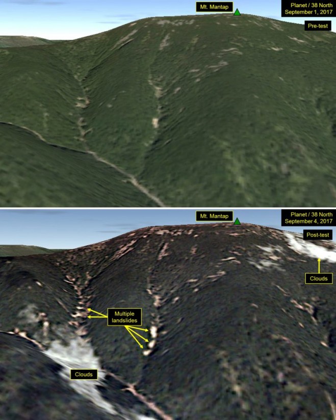
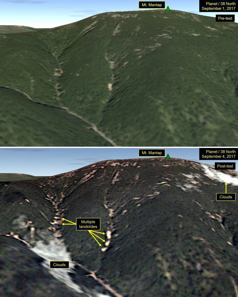
Analysts peering at satellite images of North Korea after its latest nuclear test spotted many landslides and wide disturbances at the country’s test site. Tunnels for the nuclear blasts are deep inside Mount Mantap, a mile-high peak.

“These disturbances are more numerous and widespread than what we have seen from any of the five tests North Korea previously conducted,” three experts wrote in an analysis for 38 North, a website run by the U.S.-Korea Institute of the Johns Hopkins University School of Advanced International Studies.

Early readings from global networks that monitor shock waves suggest that the nuclear blast had a destructive power equal to 120,000 tons of high explosives. If correct, that’s roughly six times more powerful than North Korea’s test of September 2016, and eight times larger than the bomb dropped on Hiroshima in 1945.

The new satellite images of the Punggye-ri nuclear test site were taken the day after the nuclear detonation. Planet, a company in San Francisco that owns swarms of tiny satellites, reconnoitered the secretive nuclear test site.
Satellite images show Mount Mantap on Sept. 1, 2017, and Sept. 4, 2017, before and after North Korea’s latest nuclear test deep under the mountain. (Credit: Planet)

Click here for more information.