Tuesday, October 25th, 2016
EuroGeographics has announced a new Management Board comprising senior representatives from Europe’s National Mapping, Cadastre and Land Registry Authorities. During the Association’s 2016 General Assembly in Budapest, Hungary, members elected Anne Cathrine Frøstrup, Norwegian Mapping Authority; Konstantin...
Tuesday, October 25th, 2016
COLORADO SPRINGS, Colo. — The Sanborn Map Company, Inc. (Sanborn) has completed a project for Boone County GIS (BCGIS), Burlington, Ky., comprising the acquisition and delivery of oblique imagery and orthoimagery for the 256-square-mile county. Geospatial and...
Tuesday, October 25th, 2016
AIRPORT CITY, Israel — OriginGPS, one of the leading manufacturers of miniature Global Navigation Satellite System (GNSS) modules, announced today the launch of three new products built on the flash-based SiRFstar V from Qualcomm Technologies, Inc. This...

Monday, October 24th, 2016
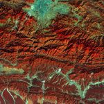
The European Space Agency (ESA) Copernicus Sentinel satellite captured this false-color image of part of Nepal, including its capital city, Kathmandu, and the Himalayan foothills. Vegetation appears red, while waterways and buildings appear light green and blue....
Monday, October 24th, 2016
The International Year of Global Understanding (IYGU) Story Maps Competition is a contest aimed at young people from around the world to help raise awareness of the global implications of local everyday actions. Our world faces social,...
Monday, October 24th, 2016
A few months ago Maptiks announced their web map analytics for Esri’s ArcGIS Online. It made it possible for ArcGIS Online users to track visitor activities, helping to answer key questions like “how and where are users...
Monday, October 24th, 2016
Each Global Spatial Data Infrastructure Association (GSDI) Conference brings together engaging speakers and specialists from around the world to explore the challenges and innovations related to increasing access to and use of geospatial data. The overall theme...
Friday, October 21st, 2016
Scottsdale, AZ, USA – Today, Hemisphere GNSS announces the Eclipse P328, the next offering in a line of new and refreshed, low-power, high-precision, positioning OEM boards. The multi-frequency, multi-GNSS P328 is an all signals receiver board that...
Friday, October 21st, 2016
Aerial mapping from Bluesky is helping to reduce the risk of trees falling on power lines, key roads and railways. Part of an NERC (Natural Environment Research Council) funded project, 3D data produced by Bluesky is being...
Friday, October 21st, 2016
Global smart-mapping leader Esri today unveiled its gold sponsorship of IBM World of Watson, to be held October 24 to 27 at Mandalay Bay in Las Vegas, Nevada. The IBM World of Watson conference will demonstrate a...