Asian Surveying & Mapping
Breaking News
Ecolab and ITE partners to harness water management knowledge for Singapore data center engineers
SINGAPORE, 29 APRIL 2024 – Nalco Water, an Ecolab...
NASA releases satellite photos of Dubai and Abu Dhabi before and after record flooding
NASA released photos of parts of Dubai and Abu...
Singapore releases 10-year Geospatial Master Plan
Singapore has launched its new Geospatial Master Plan (2024–33),...
Japan announces plans to launch upgraded observation satellites on new flagship rocket’s 3rd flight
TOKYO (AP) — Japan’s space agency announced Friday a...
Tesla China partners with Baidu for maps to clear FSD hurdle
Amidst Elon Musk’s unannounced trip to Beijing, China this...
ESA opens ideas factory to boost space innovation in Austria
A centre to innovate the design and manufacture of...
Japan’s space agency sets June 30 as third launch date for H3 rocket
The Japan Aerospace Exploration Agency (JAXA) announced Friday that...
S. Korea launches nanosatellite for Earth observation
SEOUL- A South Korean nanosatellite was launched into orbit...
Australian Space Agency funds development of aerospace-grade GNSS receiver
The Australian Space Agency has funded the development of...
Continuity risks for Australian EO data access
A new report details the widespread use of Earth...
Sundarbans OilSpill

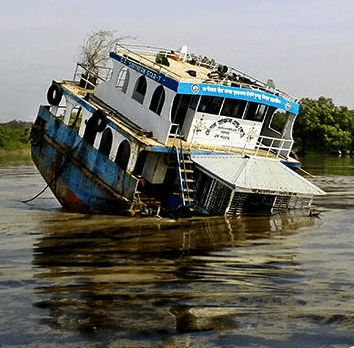
The Save the Sundarbans website was quickly stood up for the sharing of iformation. Thousands of concerned people joined and the group was quickly working with the Environment Ministry of Bangladesh, USAID and the Nishorgo network to assess the damage and assis with oil spill management.

The mapping of the damages from the spill was done by an onsite team that coordinated with UN teams.

Students from Shahjalal University of Science and Technology used a drone to help map the environmental damage. The quadcopter with a camera was able to get above the mangrove forest terrain, which is difficult to navigate on foot, to take pictures of the damage.

The sundarbans are home to rare Bengal tigers and freshwater dolphins. 

View of map of the damage on the UNOSAT site here: https://www.flickr.com/photos/worldworldworld/15883933638/