Asian Surveying & Mapping
Breaking News
South Korea is converting an abandoned coal mine into a moon exploration testing ground
South Korea is transforming abandoned coal mines into testing...
ISRO to Launch Chandrayaan-5 With Japan, Plans Space Station
Dr. V. Narayanan, Chairman of the Indian Space Research...
Russia and China are threatening SpaceX’s Starlink satellite constellation, new report finds
SpaceX's Starlink satellite constellation is facing threats from Russia...
China and Pakistan agree to fly 1st foreign astronaut to Chinese space station
For the first time, the Chinese space program will train...
ISRO’s “Space on Wheels” offers a peek into Indian Space Programme to students in Karimnagar
The Indian Space Research Organisation (ISRO)’s “Space on Wheels”...
Geospatial led solutions build the foundations for better decision-making
Geo Connect Asia 2025 paves the way for turning...
GEOSA, Singapore Land Authority Launch Achievements of Joint Geospatial System Project
Riyadh, SPA -- The General Authority for Survey and...
Building in Bangkok collapses as powerful earthquake hits southeast Asia
One person has died and 50 were injured in...
Bellatrix Aerospace Partners with Astroscale Japan for Space Debris Removal
Bellatrix Aerospace, a Bengaluru-based space mobility company, has joined...
NSTC announces Pingtung site as Taiwan’s space mission launch center
Taipei, March 26 (CNA) Taiwan's National Science and Technology...
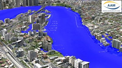
AAM_Flood_Image_Simulated_6_small

The flood simulations were featured extensively on Australian and International media. The videos supplied residents, business owners and the public with realistic representations of the predicted flood event.

The flood simulation was based on accurate geospatial terrain data created by AAM. AAM provides Engineers and Planners with photo realistic 3D City Models and highly accurate terrain models to aid in their assessment and design tasks.
AAM General Manager, Brian Nicholls, says that he hopes that AAM’s simulationshelp in some way to communicate the scale and extent of the flooding. “We hope that the recent events in Queensland will prompt greater consideration to be given to highresolution mapping, which can then be used to help manage future flood events in manyareas of Australia at risk.”
The videos are accessible on YouTube or the AAM Website. They continue to befeatured on Australian and International media.

Read More