Asian Surveying & Mapping
Breaking News
Ecolab and ITE partners to harness water management knowledge for Singapore data center engineers
SINGAPORE, 29 APRIL 2024 – Nalco Water, an Ecolab...
NASA releases satellite photos of Dubai and Abu Dhabi before and after record flooding
NASA released photos of parts of Dubai and Abu...
Singapore releases 10-year Geospatial Master Plan
Singapore has launched its new Geospatial Master Plan (2024–33),...
Japan announces plans to launch upgraded observation satellites on new flagship rocket’s 3rd flight
TOKYO (AP) — Japan’s space agency announced Friday a...
Tesla China partners with Baidu for maps to clear FSD hurdle
Amidst Elon Musk’s unannounced trip to Beijing, China this...
ESA opens ideas factory to boost space innovation in Austria
A centre to innovate the design and manufacture of...
Japan’s space agency sets June 30 as third launch date for H3 rocket
The Japan Aerospace Exploration Agency (JAXA) announced Friday that...
S. Korea launches nanosatellite for Earth observation
SEOUL- A South Korean nanosatellite was launched into orbit...
Australian Space Agency funds development of aerospace-grade GNSS receiver
The Australian Space Agency has funded the development of...
Continuity risks for Australian EO data access
A new report details the widespread use of Earth...
  • Nov 7, 2023
  • Comments Off on Understanding the Actual Magnitude of Earthquakes in Afghanistan and Morocco 
  • Feature
  • 516 Views

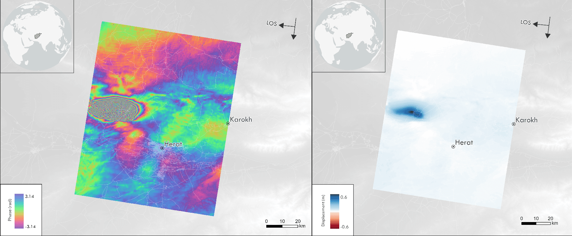
In September and October 2023, Afghanistan and Morocco were hit by strong earthquakes. In Morocco, where such phenomena are quite uncommon, and in Afghanistan, they wiped out entire villages, killing thousands of people. Using satellite data, Dr. Laurynas Jukna and Elzė Buslavičiūtė, geographers at the Institute of Geosciences of Vilnius University (VU), revealed the actual magnitude of these earthquakes and explained how they can be tracked by employing modern satellite technology.  

The Herat Province is located close to the junction of the Arabian, Indian and Eurasian plates, which means that earthquakes are quite common in this region. In western and central Afghanistan, it’s the northward movement of the Arabian Plate that has the greatest impact. On Oct. 8, 2023, the morning after the earthquake, the Sentinel-1 satellite data was made available for this area. The images showed the deformation of the surface between Sept. 26, 2023 and Oct. 8, 2023. The sequence of colors from blue to purple points to a ~3 centimeters deformation in the satellite LOS direction. The darker the color, the more severe the deformation; thus, we can see the densification of these fringes near the epicentre. In the blue area, the maximum deformation close to the epicenter reaches 60 centimeters in the satellite LOS direction.