Asian Surveying & Mapping
Breaking News
Swift Navigation and SK Telecom Partner to Accelerate the Deployment of AI-Powered Location-Based Products in Korea
SAN FRANCISCO - Swift Navigation (“Swift”), a market leader...
Esri India Achieves 1 Million Users Milestone
Esri India, the leading provider of Geographic Information System...
Bank Negara, Malaysian Space Agency to bolster financial management ecosystem via space technology
KUALA LUMPUR: Bank Negara Malaysia has partnered with the...
Nepal’s president advisor resigns after criticising inclusion of Indian areas in map on new currency
The economic advisor to Nepal’s president on Sunday (May...
TASA to launch six satellites from 2026
The Taiwan Space Agency (TASA) yesterday said it plans...
Japan to provide flood risk maps for four South-East Asian countries – Indonesia, Vietnam, Thailand and Cambodia
JAKARTA/TOKYO: Japan plans to start providing flood risk maps...
Ecolab and ITE partners to harness water management knowledge for Singapore data center engineers
SINGAPORE, 29 APRIL 2024 – Nalco Water, an Ecolab...
NASA releases satellite photos of Dubai and Abu Dhabi before and after record flooding
NASA released photos of parts of Dubai and Abu...
Singapore releases 10-year Geospatial Master Plan
Singapore has launched its new Geospatial Master Plan (2024–33),...
Japan announces plans to launch upgraded observation satellites on new flagship rocket’s 3rd flight
TOKYO (AP) — Japan’s space agency announced Friday a...

In the 1970s, Nepal was facing an environmental crisis. Forests in Nepal’s hillsides were being degraded due to livestock grazing and fuelwood harvesting, which led to increased flooding and landslides. Without large-scale reforestation programs, a 1979 World Bank report warned, forests in the country’s hills would be largely gone by 1990. 

In the 1980s and 1990s, Nepal’s government began to reassess its national-level forest management practices, which led to a pivotal forestry act in 1993. This legislation allowed Nepal’s forest rangers to hand over national forests to community forest groups. The result of this community-led management, recent NASA-funded research has found, was a near-doubling of forest cover in the small mountainous country. 

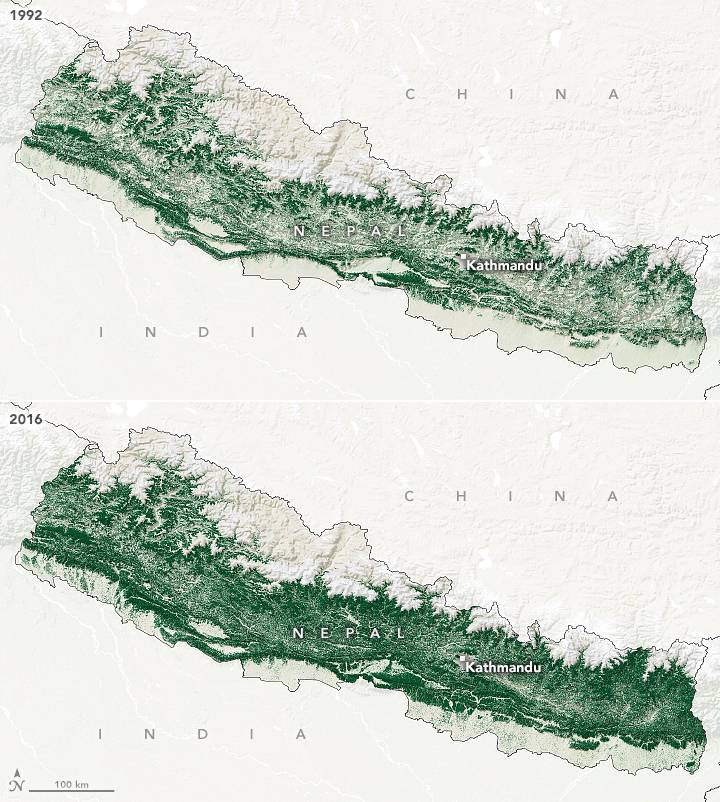
The accompanying maps show forest cover in Nepal in 1992 (top) and 2016 (bottom). Between these years, forest cover in the country almost doubled, from 26 percent to 45 percent. Using the long-term data record from Landsat satellites, along with in-depth interviews with people in Nepali villages, the research group found that community forest management was associated with the regrowth of forests. Most of the tree regrowth happened in middle-elevations, in the hills between the Himalayas and the plains of the Ganges River.

Image Credit: NASA Earth Observatory images by Lauren Dauphin, using data from Van Den Hoek, J., et al. 2021