
In the 1970s, Nepal was facing an environmental crisis. Forests in Nepal’s hillsides were being degraded due to livestock grazing and fuelwood harvesting, which led to increased flooding and landslides. Without large-scale reforestation programs, a 1979 World Bank report warned, forests in the country’s hills would be largely gone by 1990.
In the 1980s and 1990s, Nepal’s government began to reassess its national-level forest management practices, which led to a pivotal forestry act in 1993. This legislation allowed Nepal’s forest rangers to hand over national forests to community forest groups. The result of this community-led management, recent NASA-funded research has found, was a near-doubling of forest cover in the small mountainous country.
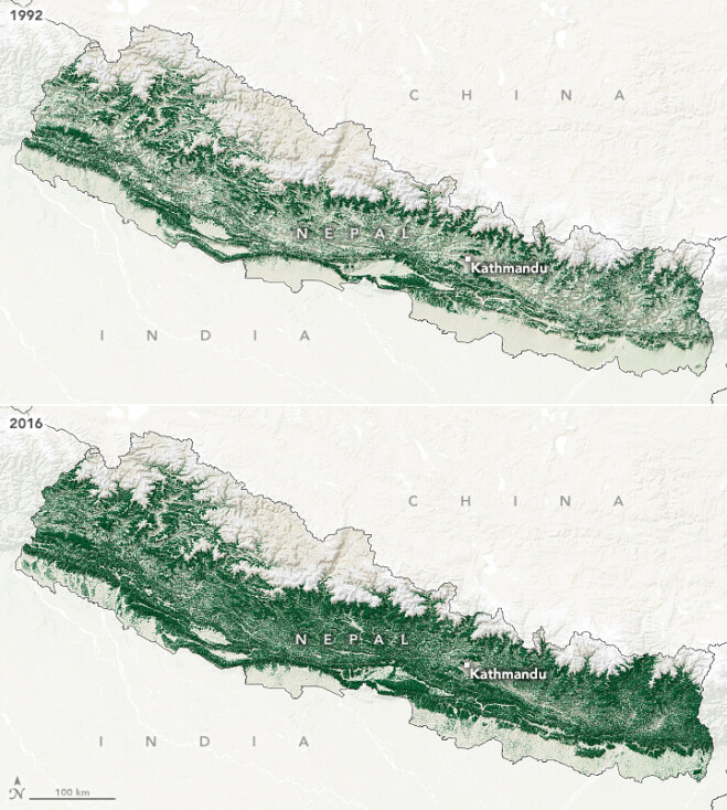
The accompanying maps show forest cover in Nepal in 1992 (top) and 2016 (bottom). Between these years, forest cover in the country almost doubled, from 26 percent to 45 percent. Using the long-term data record from Landsat satellites, along with in-depth interviews with people in Nepali villages, the research group found that community forest management was associated with the regrowth of forests. Most of the tree regrowth happened in middle-elevations, in the hills between the Himalayas and the plains of the Ganges River.
Image Credit: NASA Earth Observatory images by Lauren Dauphin, using data from Van Den Hoek, J., et al. 2021