Asian Surveying & Mapping
Breaking News
Esri India Achieves 1 Million Users Milestone
Esri India, the leading provider of Geographic Information System...
Bank Negara, Malaysian Space Agency to bolster financial management ecosystem via space technology
KUALA LUMPUR: Bank Negara Malaysia has partnered with the...
Nepal’s president advisor resigns after criticising inclusion of Indian areas in map on new currency
The economic advisor to Nepal’s president on Sunday (May...
TASA to launch six satellites from 2026
The Taiwan Space Agency (TASA) yesterday said it plans...
Japan to provide flood risk maps for four South-East Asian countries – Indonesia, Vietnam, Thailand and Cambodia
JAKARTA/TOKYO: Japan plans to start providing flood risk maps...
Ecolab and ITE partners to harness water management knowledge for Singapore data center engineers
SINGAPORE, 29 APRIL 2024 – Nalco Water, an Ecolab...
NASA releases satellite photos of Dubai and Abu Dhabi before and after record flooding
NASA released photos of parts of Dubai and Abu...
Singapore releases 10-year Geospatial Master Plan
Singapore has launched its new Geospatial Master Plan (2024–33),...
Japan announces plans to launch upgraded observation satellites on new flagship rocket’s 3rd flight
TOKYO (AP) — Japan’s space agency announced Friday a...
Tesla China partners with Baidu for maps to clear FSD hurdle
Amidst Elon Musk’s unannounced trip to Beijing, China this...
  • Jan 30, 2023
  • Comments Off on Synchronized LiDAR and Bathymetric Surveying Methods to Study a Floating Solar Farm in Israel
  • Feature
  • 681 Views

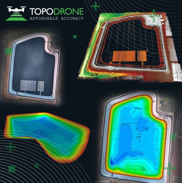
The synchronization was performed upon a request from the Israeli drone service provider ERELIS to conduct a pilot project of reservoir surveying with a UAV for ETZ HADEKEL Ltd. in Northern Israel. The surface of the reservoir is covered by solar panels, which made it difficult to carry out work using standard methods of surveying from a boat. 

ERELIS performed two-stage drone surveying to deliver a high-precision 3D model of the reservoir. First, aerial photogrammetry and LiDAR surveys were performed using a DJI M300 drone equipped with a TOPODRONE camera P61 and a LiDAR HI-RES system to determine the location of possible obstacles. LiDAR scanning provided accurate detection of cables in the water.

Second, an underwater bathymetric survey using a TOPODRONE AQUAMAPPER mounted to the same drone was conducted avoiding detected obstacles (cables, solar panels and other objects). The flight mission was planned and executed with the UgCS software by SPH Engineering.

The collected LiDAR & bathymetry data was processed by TOPODRONE Post Processing software. As a result, a georeferenced orthophoto map, a 3D model of the relief and objects, a 3D model of the bottom of the reservoir, contour lines and isobaths were generated. Such 3D models can be used for high-precision assessment of sediment volumes, general monitoring of reservoir banks and visual monitoring. In addition, surveying with a TOPODRONE AQUAMAPPER made it possible to estimate sludge deposits of the reservoir. 

Image Credit: TOPODRONE