Asian Surveying & Mapping
Breaking News
Australian Space Agency funds development of aerospace-grade GNSS receiver
The Australian Space Agency has funded the development of...
Continuity risks for Australian EO data access
A new report details the widespread use of Earth...
China launches new remote sensing satellite
JIUQUAN, April 15 (Xinhua) -- China on Monday launched...
7.4-Magnitude Earthquake Strikes Taiwan
A major, 7.4-magnitude earthquake struck the eastern coast of...
Tata Deploys Its Geospatial Satellite In Space on Space X’s Falcon 9 Rocket
THIRUVANANTHAPURAM: Tata Company launched India's first private commercial satellite...
Taiwan’s Formosat-8 Satellite Set for Launch by 2025
The Taiwan Space Agency has announced progress on the...
Iranian Scientists to Build Satellite Constellation for 2 Simultaneous Missions
The scientists at the knowledge-based company had previously succeeded...
China provides geospatial intel and other military support to Russia, US says
The US has warned its European allies that China...
Japanese lunar lander company ispace raises $53.5 million in stock sale
WASHINGTON — Japanese lunar lander developer has raised $53.5...
Esri and Prince Sultan University Advance GIS Education Through Strategic Partnership
Memorandum of Understanding with Institution Enhances GIS Curriculum and...

After an extremely wet October, southeast Australia continued to see heavy rainfall in November 2022. With soils already saturated and dams full, the latest storms have added to ongoing flooding across New South Wales and Victoria.

In the week leading up to Nov. 14, 2022, large parts of New South Wales and Victoria saw more than 50 millimeters of rain (2 inches). The town of Forbes, New South Wales, had the highest daily total for the week. It saw 118 millimeters (4.6 inches) fall in a 24-hour period spanning November 13-14. The abundant rain across the region caused rivers to rise and flood nearby towns. Forbes saw its third major flood event in just four weeks as waters on the Lachlan River rose faster than expected.

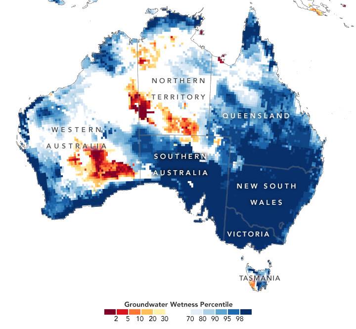
Water that seeps deep into the soil can influence groundwater levels for months. The accompanying map depicts shallow groundwater storage in Australia from Nov. 11-14, 2022, as measured by the Gravity Recovery and Climate Experiment Follow-On (GRACE-FO) satellites. The colors depict the wetness percentile; that is, how the levels of groundwater compare to long-term records (1948-2012). Blue areas have more abundant water than usual, and orange and red areas have less.