Asian Surveying & Mapping
Breaking News
Ecolab and ITE partners to harness water management knowledge for Singapore data center engineers
SINGAPORE, 29 APRIL 2024 – Nalco Water, an Ecolab...
NASA releases satellite photos of Dubai and Abu Dhabi before and after record flooding
NASA released photos of parts of Dubai and Abu...
Singapore releases 10-year Geospatial Master Plan
Singapore has launched its new Geospatial Master Plan (2024–33),...
Japan announces plans to launch upgraded observation satellites on new flagship rocket’s 3rd flight
TOKYO (AP) — Japan’s space agency announced Friday a...
Tesla China partners with Baidu for maps to clear FSD hurdle
Amidst Elon Musk’s unannounced trip to Beijing, China this...
ESA opens ideas factory to boost space innovation in Austria
A centre to innovate the design and manufacture of...
Japan’s space agency sets June 30 as third launch date for H3 rocket
The Japan Aerospace Exploration Agency (JAXA) announced Friday that...
S. Korea launches nanosatellite for Earth observation
SEOUL- A South Korean nanosatellite was launched into orbit...
Australian Space Agency funds development of aerospace-grade GNSS receiver
The Australian Space Agency has funded the development of...
Continuity risks for Australian EO data access
A new report details the widespread use of Earth...
borneo-deforestation

The Earth Watchers application has harnessed a worldwide audience of young people that act as agents to monitor the rainforest through web-based GIS and current satellite images. Using these tools, the agents pull together detailed reports of their findings to share with their peers. The application provides a fun way to learn about the application of GIS and remote sensing technology, while giving students a global cause of imprtance as motivation.

“Many people are worried about the condition of the rainforest here and would like to make a contribution to finding a solution,” said Eduardo Dias, director of Geodan Southeast Asia. “With our project, we make it possible for everyone to take action themselves. This way, people are part of the solution and, using the Earthwatchers application, they are able to see for themselves what is happening.”

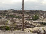
DeforestACTION is a worldwide action plan designed to help save the rainforest in Borneo. They worked with Geodan, a geo-ICT consulting firm based in the Netherlands, to create the specialized tool. 

The main objectives of this project are to:

  • Involve students worldwide in the forest conservation effort via Satellite Earth Observation
  • Make available and accessible different geographic layers of the area for the students to explore and understand the inter-relationship between biotic and abiotic factors in forest conservations (biodiversity layer, forest density, human accessibility and infrastructure, carbon deposits, etc)
  • Develop crowdsourcing tools and techniques for human computation of radar earth observation deployed on a webGIS environment linked to social media to enable collaborative intelligence and improving the system by self-learning on results
  • Create awareness/learning materials about earth observation
  • Protect the forest: by deploying a team in-situ who can confirm/de-confirm the illegal deforestation suggested by the students and engage the local authorities to stop it
  • Prove that useful results can be harnessed from radar earth observation analyzed using human computation

In additon to the worldwide crowdsourcing effort, there are local teams that will survey the top ten most confirmed sites every week. With proof of illegal activities, they can then form outreach to local communities and the government to enforce the law and put a stop to illegal logging.