Asian Surveying & Mapping
Breaking News
Australia’s Gilmour Space Technologies ready to launch maiden Eris Test flight the nation’s first orbital launch in over 50 years
Gilmour Space Technologies is the leading launch services company...
Korea’s space agency seeks revision of plan to modify next-gen rockets into reusable system
South Korea's aerospace agency said on Thursday that it...
UAE Space Agency Signs Agreement With Technology Innovation Institute to Execute the Emirates Mission to the Asteroid Belt’s Lander Project
In the presence of His Highness Sheikh Hamdan bin...
Private Japanese lunar lander enters orbit around moon ahead of a June touchdown
A private lunar lander from Japan is now circling the moon, with...
Indian astronaut to travel soon to ISS as part of ISRO-NASA Mission
Prime Minister Narendra Modi said by 2040, an Indian’s...
China issues regulatory framework to support direct-to-device satellite services
HELSINKI — China has released comprehensive regulations for direct-to-device...
Astranis clinches $115 million Taiwan deal despite satellite setback
TAMPA, Fla. — Astranis has signed a $115 million...
UAE and Egypt Strengthen Space Collaboration with New MoU
In a milestone development for Arab space collaboration, the...
Seoul launches 4th spy satellite to boost North Korea surveillance
South Korea’s military now operates an increasingly integrated cluster...
Indonesia seeks space defense cooperation with Japan’s military
Jakarta (ANTARA) - The Ministry of Defense of Indonesia...
URA3D

The combination of 3D technology with 2D GIS technology has provided URA staff and their community with the tools to visualize the impact of urban development. The visual analysis provides a value added segment to the evaluation processes supporting the most educated decisions when building a greater Singapore.

The use of 3D visualization has become a tool for Singapore’s marketing and communication of their land use plans. Quantitative impacts were given in terms of both “man-days” and monies saved to date, along with estimates of future benefits.

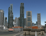
Many different groups are now making use of the system and specific examples were given of projects and studies that used the system, along with visual representations for each. This is a unique application in that it presents an innovative system for producing visualizations of Singapore. The videos and images produced by the solution portray the vision of and for Singapore. Projects like these move the GIS and planning industries forward.

This and other exemplary systems will be celebrated during the Awards Breakfast at GIS-Pro 2011: URISA’s 49th Annual Conference in Indianapolis on November 3, 2011.