Asian Surveying & Mapping
Breaking News
Esri India Achieves 1 Million Users Milestone
Esri India, the leading provider of Geographic Information System...
Bank Negara, Malaysian Space Agency to bolster financial management ecosystem via space technology
KUALA LUMPUR: Bank Negara Malaysia has partnered with the...
Nepal’s president advisor resigns after criticising inclusion of Indian areas in map on new currency
The economic advisor to Nepal’s president on Sunday (May...
TASA to launch six satellites from 2026
The Taiwan Space Agency (TASA) yesterday said it plans...
Japan to provide flood risk maps for four South-East Asian countries – Indonesia, Vietnam, Thailand and Cambodia
JAKARTA/TOKYO: Japan plans to start providing flood risk maps...
Ecolab and ITE partners to harness water management knowledge for Singapore data center engineers
SINGAPORE, 29 APRIL 2024 – Nalco Water, an Ecolab...
NASA releases satellite photos of Dubai and Abu Dhabi before and after record flooding
NASA released photos of parts of Dubai and Abu...
Singapore releases 10-year Geospatial Master Plan
Singapore has launched its new Geospatial Master Plan (2024–33),...
Japan announces plans to launch upgraded observation satellites on new flagship rocket’s 3rd flight
TOKYO (AP) — Japan’s space agency announced Friday a...
Tesla China partners with Baidu for maps to clear FSD hurdle
Amidst Elon Musk’s unannounced trip to Beijing, China this...
Beijing_GEOSS

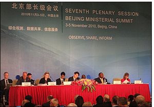
The importance of the GEOSS effort was outlined in the Beijing declaration, which welcomed a “future wherein decisions and actions for the benefit of humankind are more fully informed by Earth observations, science and associated information products and services.” The declaration recognized that the Global Earth Observation System of Systems (GEOSS) represents a critical step towards advancing the goals and implementation of international environmental treaties and contributes significantly to addressing climate change, enhancing human health and safety, protecting the global environment, achieving food security, alleviating poverty and harnessing knowledge and innovation for social, environmental and economic well-being.

GEO’s forest carbon tracking activities received strong support, with the creation of the Global Forest Observation Initiative. Governments also recognized the importance of GEO activities for the REDD-plus Partnership, the Climate Change Convention, and other forest-related activities. The GEO Biodiversity Observation Network was touted as an example of how GEOSS can reach out to the users of Earth observations and address the international political agenda.

Among the priorities in the coming years are:

  • adding to the number of data sets that can be accessed
  • building earth observation skills of individuals and institutions
  • linking the technical capabilities of GEO with global issues
  • attracting more users and participants
  • preparing for post-2015 operation of GEOSS

The group resolved to meet again before the end of 2013 to review progress of implementation against strategic targets, and to recommend governance and the role of future work beyond 2015.