Asian Surveying & Mapping
Breaking News
HAL to build, market Isro’s SSLV in landmark deal
New Delhi, Jun 20: In a historic move for...
Taiwan developing space capabilities for all-weather imaging
TAIPEI (TVBS News) — Taiwan is advancing its space...
Honda hails successful test of reusable rocket as it looks to get into the space business
Tokyo — Japan's second-biggest carmaker, Honda, has successfully tested...
China’s space program provides larger platform for broader international cooperation
BEIJING -- Experts from China's manned space program said...
India To Launch $1.5 Billion Joint Earth Mission With NASA In July
National Aeronautics and Space Administration (NASA) and the Indian...
Axiom-4 mission delayed again: ISRO confirms Subhanshu Shukla’s ISS spaceflight won’t launch before 22 June 2025
The Axiom-4 mission to the International Space Station has...
Mengzhou spacecraft for China’s moon-landing mission passes landmark test flight
China has completed the inaugural test flight of its...
Space application for ITMA Asia + CITME 2026 opens
Shanghai – Space application for the 2026 edition of...
Yanmar, Chia Tai and XAG Empower Thai Agriculture through Innovation
Bang Nam Priao District, Chachoengsao Province, Thailand – On...
bitsensing Signs MOU with IKIO Technologies to Advance AI-Based Traffic Monitoring on India’s Expressways, Highways and Municipal Areas
Backed by proven success in South Korea and Europe,...

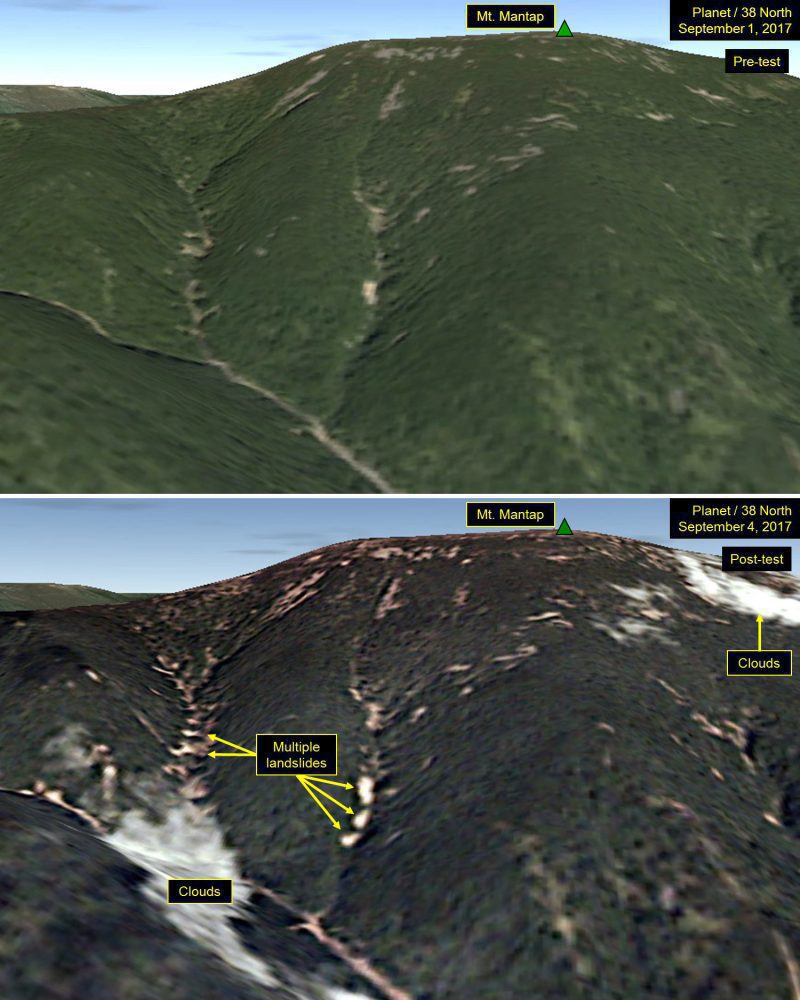
Analysts peering at satellite images of North Korea after its latest nuclear test spotted many landslides and wide disturbances at the country’s test site. Tunnels for the nuclear blasts are deep inside Mount Mantap, a mile-high peak.

“These disturbances are more numerous and widespread than what we have seen from any of the five tests North Korea previously conducted,” three experts wrote in an analysis for 38 North, a website run by the U.S.-Korea Institute of the Johns Hopkins University School of Advanced International Studies.

Early readings from global networks that monitor shock waves suggest that the nuclear blast had a destructive power equal to 120,000 tons of high explosives. If correct, that’s roughly six times more powerful than North Korea’s test of September 2016, and eight times larger than the bomb dropped on Hiroshima in 1945.

The new satellite images of the Punggye-ri nuclear test site were taken the day after the nuclear detonation. Planet, a company in San Francisco that owns swarms of tiny satellites, reconnoitered the secretive nuclear test site.

Satellite images show Mount Mantap on Sept. 1, 2017, and Sept. 4, 2017, before and after North Korea’s latest nuclear test deep under the mountain. (Credit: Planet)

Click here for more information.