Asian Surveying & Mapping
Breaking News
Ecolab and ITE partners to harness water management knowledge for Singapore data center engineers
SINGAPORE, 29 APRIL 2024 – Nalco Water, an Ecolab...
NASA releases satellite photos of Dubai and Abu Dhabi before and after record flooding
NASA released photos of parts of Dubai and Abu...
Singapore releases 10-year Geospatial Master Plan
Singapore has launched its new Geospatial Master Plan (2024–33),...
Japan announces plans to launch upgraded observation satellites on new flagship rocket’s 3rd flight
TOKYO (AP) — Japan’s space agency announced Friday a...
Tesla China partners with Baidu for maps to clear FSD hurdle
Amidst Elon Musk’s unannounced trip to Beijing, China this...
ESA opens ideas factory to boost space innovation in Austria
A centre to innovate the design and manufacture of...
Japan’s space agency sets June 30 as third launch date for H3 rocket
The Japan Aerospace Exploration Agency (JAXA) announced Friday that...
S. Korea launches nanosatellite for Earth observation
SEOUL- A South Korean nanosatellite was launched into orbit...
Australian Space Agency funds development of aerospace-grade GNSS receiver
The Australian Space Agency has funded the development of...
Continuity risks for Australian EO data access
A new report details the widespread use of Earth...

An 800-year-old puzzle about the burial place of Mongolian ruler Genghis Khan sparked a very 21st century business. Albert Lin was on an expedition to locate the lost tomb of the Mongol Empire founder, when satellite imagery firm DigitalGlobe donated some photos of potential areas for his team to scrutinise.

These images, taken from space, were enormous, and as nobody knows what the tomb actually looked like, there was no obvious place to start the search.

So the team decided to crowdsource for clues. They returned to Mongolia three times to investigate “anomalies” in the photographs, submitted by eagle-eyed armchair enthusiasts. Could one of these have been the burial site?

Alas, no, the search continues. But one of the team members, Shay Har-Noy, says: “We did find some ancient archaeological sites that are still in need of investigation.”

The experience inspired them to set up crowdsourcing platform Tomnod, which offered satellite imagery from DigitalGlobe to people running their own projects. DigitalGlobe eventually acquired the firm.

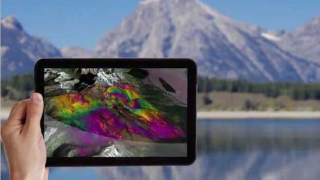
Among many other applications, shortwave infrared satellite imagery can help miners search for minerals. (Credit: DigitalGlobe)