
Tuesday, April 11th, 2017
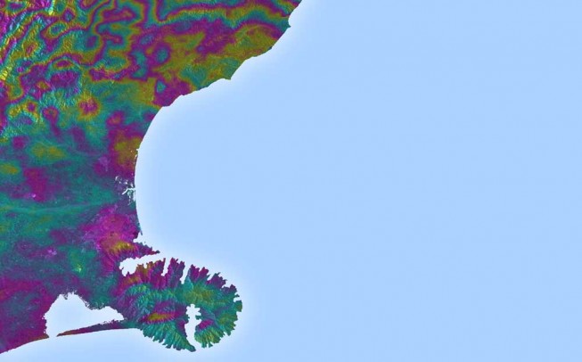
Satellite radar scans of the 7.8-magnitude Nov. 14, 2016, earthquake in New Zealand are changing the way scientists think about earthquake hazards in regions where Earth’s tectonic plates meet. The quake struck near the town of Kaikoura...

Tuesday, March 14th, 2017
If a two-year trial of Satellite Based Augmentation Systems (SBAS) being undertaken with the backing of the Australian and New Zealand governments proves successful, position fixing could become more precise than the several-meters accuracy provided by Global...

Thursday, March 15th, 2012
The Digital Earth Summit will convene for the fourth biannual event from Sept. 2-4, 2012 in Wellington, New Zealand. This event is sponsored by both the Wellington City Council and Land Information New Zealand and coordinated by...
Tuesday, February 28th, 2012
An Antarctic lobby group, backed by major conservation groups and celebrities, is calling for a massive marine reserve in the Ross Sea as part of an even bigger reserve surrounding Antarctica. It would include a substantial proportion of...
Friday, January 13th, 2012
The World Bank and the Embassy of New Zealand are collaborating with Vietnam’s Ministry of Natural Resources and Environment to develop a complete and modern land management system, in an effort to increase access to land information...
Tuesday, December 6th, 2011
IIC is pleased to announce the award of a contract from Land Information New Zealand (LINZ) for the production of 50 paper chart masters using Citrix technology and CARIS HPD. The production work will continue until mid-2012...
Tuesday, December 6th, 2011
The New Zealand Geospatial Strategy, published in January 2007, aims to better coordinate and manage the use of New Zealand's geospatial resources across all tiers of society. It addresses the increasing reliance on geospatial information in New...
Tuesday, November 29th, 2011
An author-mountaineer from New Zealand has successfully completed a 2,300-kilometer journey along North Korea’s portion of the Baekdu-Daegan mountain range, documenting the trip for an upcoming book that will offer a rare glimpse of stunning scenery. Roger Shepherd,...
Saturday, November 19th, 2011
About 40 scientists from nine countries are meeting in Oamaru this week to review results from a scientific ocean drilling expedition that took place off the coast of South Canterbury in early 2010. Using the seafloor drilling ship, JOIDES...
Thursday, October 27th, 2011
The New Zealand Ministry of Fisheries has developed a smartphone fishing application that notes the user's location via GPS positioning and provides detailed information regarding their location, including rules and other notices. This application won the Wireless...
